H-DK
The H-DK Mosaic H GNSS receiver, powered by the advanced Septentrio Mosaic H core, delivers high precision and reliability in GNSS-based applications. Featuring integrated AIM+, IONO+, and APME+, the H-DK ensures superior performance in challenging environments, including urban canyons and areas with high interference. Its compact design makes it versatile and easy to integrate into a wide range of applications such as autonomous vehicles, drones, geospatial mapping, and surveying. With robust signal tracking capabilities and support for multiple GNSS constellations, the H-DK Mosaic H is a top choice for industries requiring high-accuracy navigation solutions.
Description
The H-DK GNSS receiver is powered by the Septentrio Mosaic H core, designed to offer high accuracy and reliability for demanding applications. With specialized features such as AIM+ (Advanced Interference Mitigation), IONO+ (Ionospheric Delay Modeling), and APME+ (Advanced Multipath Estimation), the H-DK is an ideal and highly effective solution for precise positioning needs.
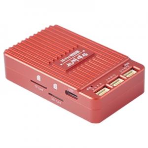
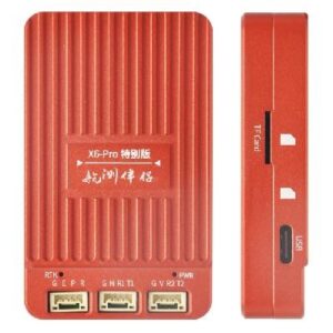
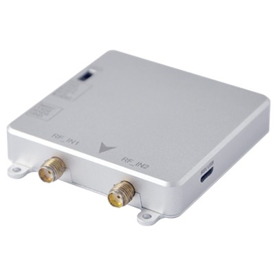
Measuring at just 59mm (W) × 71mm (L) × 12mm (H), this module is engineered for use in a wide range of industries, from UAVs to autonomous vehicles and beyond. The H-DK is built to provide high-quality GNSS data even in demanding conditions, , offering greater accuracy and reliability than conventional GNSS modules.
Whether you’re working in remote locations, through urban canyons, or in areas with high signal interference, the H-DK ensures that you achieve precise positioning with ease. It’s the ideal solution for those who require compact, powerful, and efficient GNSS technology for their applications.
H-DK Specifications:
- GNSS Core: Septentrio Mosaic H
- Special Features: AIM+, IONO+, APME+
- Dimensions: 59mm (W) × 71mm (L) × 12mm (H)
- Power Consumption: Low power requirements, optimized for efficiency
- Accuracy: High-precision positioning with <1 cm RTK accuracy (depending on application and conditions)
- Interfaces: Supports multiple communication protocols for easy integration
- Environmentally Rugged: Operates in challenging environments, resistant to interference and signal blockage
MOSAIC-H module features:
- 31.0 x 31.0 x 4.2 mm LGA package
- Supports all-constellatiion multi-frequency on-chip RTK positioning and dual-antenna heading solution
- Supports GPS L1/L2, BDS B1I/B2I/B3I, GLONASS G1/G2, Galileo E1/E5b and QZSS L1/L2
- All-system multi-frequency RTK engine and advanced RTK technology
- AIM+: Industry leading Anti-jamming, Anti-sppofing Interference Monitoring and Mitigation
- IONO+: Advanced protection against ionospheric disturbances to GNSS signals
- APME+: a posteriori multipath estimator for code and phase multipath mitigation
- LOCK+: superior tracking robustness under heavy mechanical shocks or vibration
- RAIM+: Advanced Receiver Autonomous Integrity Monitoring
Performance Specifications:
Frequency
- GPS L1C/A/L2P (Y)/L2C
- BDS B1I/B2I/B3I
- GLONASS G1/G2
- Galileo E1/E5b
- QZSS L1C/A, L1C/B, L2C
Single point positioning (RMS):
- Horizontal: 1.2 m
- Vertical: 1.9 m
- Time Precision(xPPS out) – 5 ns
- Data Update Rate: 100 Hz
DGPS (RMS):
- Horizontal: 0.4 m
- Vertical: 0.7 m
- Cold start < 45 s
- Initialization Time < 1 s (typical)
- Data Update Rate: 50 Hz
RTK (RMS):
- Horizontal: 0.6 cm + 0.5 ppm
- Vertical: 1cm + 1 ppm
- Data Update Rate: 20 Hz
- Differential Data – RTCM V2.x, V3.X (MSM included), CMR v2.0/CMR+ (input only)
- Data Format – NMEA-0183, v2.3, v3.03, v4.0, RINEX v2.x, v3.x, Septentrio Binary Format (SBF)
Physical Characteristics:
- Packaging: 239 pin LGA
- Dimension: 31.0 × 31.0 × 4.2 mm
- Weight: 6.8g
Environmental Specifications:
- Working temperature: -40 °C ~ +85 °C
- Storage temperature: -55 °C ~ +85°C
- Humidity: 95% No condensation
- Vibration: MIL-STD-810G
Communication Interfaces:
- 4 × UART (3 with hardware flow control)
- 1 × USB (2.0, HS)
- 1 × Ethernet (RMII/MDIO), 10/100 Mbps
- 1 x SD memory card
- 2 x Event inputs
- 2 x GPIO
- 1 x PPS out
H-DK GNSS Features:
GNSS Core: Septentrio Mosaic H for reliable and high-precision positioning
Special Features: AIM+, IONO+, APME+ for enhanced performance in challenging environments
Compact Design: Dimensions of 59mm (W) × 71mm (L) × 12mm (H) for easy integration into space-constrained applications
Interference Mitigation: Advanced capabilities to reduce signal interference for more accurate results
Multipath and Ionospheric Delay Modeling: Reduces errors caused by multipath effects and ionospheric disturbances
High Reliability: Provides consistent, high-quality GNSS data for various industries and applications
Product datasheet
Applications of HDK:
Unmanned Aerial Vehicles (UAVs): Perfect for drones that need to be positioned and navigated precisely, it guarantees precise waypoint following, steady hovering, and trustworthy georeferencing for LiDAR scanning and aerial photography. GNSS receivers improve flight efficiency, particularly in difficult conditions like crowded cities or rough terrain.
Precision Agriculture: allows for accurate tractor guidance, crop monitoring, and effective field mapping at the centimeter level. In order to reduce waste and increase crop yields, GNSS-powered systems make tasks like variable rate fertilizer application, seed planting, and irrigation management easier.
Surveying & Mapping: offers the high-accuracy positioning required for land surveys, construction site planning, and infrastructure development. GNSS receivers enable real-time corrections, faster data collection, and integration with GIS software to create complex maps and 3D models.
Robotics: ideal for robots that need to navigate in dynamic environments and track precise locations. Robotic systems, such as delivery, warehouse, and search-and-rescue robots, can move consistently and effectively even in environments with few visual cues thanks to GNSS data.
Geospatial Data Collection: Perfect for asset tracking applications, environmental monitoring projects, and GIS specialists. Even in difficult or remote locations, GNSS receivers guarantee precise data collection for tasks like infrastructure maintenance, urban planning, disaster response, and natural resource management.
Specifications of M9 GNSS:
GNSS Signals:
- 544 hardware channels for simultaneous tracking of most visible signals:
- GPS: L1 C/A, L2C, L2 P(Y), L5
- GLONASS: L1 C/A, L2C/A, L3, L2P
- BeiDou: B1I, B1C, B2a, B2I, B3I
- Galileo: E1, E5a, E5b
- QZSS: L1 C/A, L1C, L2C, L5
- SBAS: EGNOS, WAAS, GAGAN, MSAS, SDCM
- Integrated L-band receiver
Septentrio’s Patented GNSS+ Technologies:
- AIM+: Anti-jamming and monitoring system for narrow and wideband interference, including spectrum analyzer
- IONO+: Advanced scintillation mitigation
- APME+: A posteriori multipath estimator for code and phase multipath mitigation
- LOCK+: Superior tracking robustness under mechanical shocks or vibrations
- RAIM+: Receiver Autonomous Integrity Monitoring
Formats Supported:
- Septentrio Binary Format (SBF): Fully documented with sample parsing tools
- NMEA 0183: v3.01, v4.0
- RTCM: v2.x, v3.x (including MSM messages)
- CMR: v2.0 and CMR+ (CMR+ input only)
Connectivity:
- 4 Hi-speed serial ports (LVTTL)
- 1 USB device port (TCP/IP communication, plus 2 extra serial ports)
- xPPS output (max 100Hz)
- Ethernet port (TCP/IP, UDP, LAN 10/100 Mbps)
- 2 Event markers (for external LEDs)
- General-purpose output
- NTRIP (server, client, caster)
- FTP server, FTP push, SFTP
Supporting Components:
- Web UI: Full control and monitoring functionality
- RxTools: Complete and intuitive GUI toolset for receiver control, monitoring, data analysis, and conversion
- GNSS Receiver Communication SDK: Available for both Windows and Linux
Performance
RTK Performance:
- Horizontal accuracy: 0.6 cm + 0.5 ppm
- Vertical accuracy: 1 cm + 1 ppm
- Initialization time: 7 seconds
GNSS Attitude Accuracy:
- Antenna separation:
- 1 m: Heading 0.15°, Pitch/Roll 0.25°
- 5 m: Heading 0.03°, Pitch/Roll 0.05°
Position Accuracy:
- Standalone:
- Horizontal: 1.2 m
- Vertical: 1.9 m
- SBAS:
- Horizontal: 0.6 m
- Vertical: 0.8 m
- DGNSS:
- Horizontal: 0.4 m
- Vertical: 0.7 m
Velocity Accuracy: 0.03 m/s
Maximum Update Rate:
- Measurements only: 100 Hz
- Position and Attitude: 20 Hz
- Latency: <10 ms
Time Precision:
- xPPS output: 5 ns
- Event accuracy: < 20 ns
Time to First Fix:
- Cold start: < 45 s
- Warm start: < 20 s
- Re-acquisition: avg. 1 s
Tracking Performance (C/N0 Threshold):
- Tracking: 20 dB-Hz
- Acquisition: 33 dB-Hz
Optional Accessories:
- Antennas
- GeoTagZ Re-processing Software and SDK library for UAS applications
- Robotics Interface Board
Physical and Environmental Specifications:
Size:
- 47.5 x 70 x 9.32 mm (1.87 x 2.75 x 0.36 in)
Weight: 27 g (0.952 oz)
Input Voltage: 3.3 VDC ± 5%
Power Consumption:
- GPS L1/L2: 750 mW
- GPS/GLO L1/L2: 800 mW
- All GNSS signals: 1000 mW
Antenna:
- Connectors: 2 x MMCX
- Antenna supply voltage: 3-5.5 VDC
- Maximum antenna current: 150 mA
- Antenna gain range: 15-45 dB
I/O Connectors:
- 30 Pins Hirose DF40 socket
- 60 Pins Hirose DF40 socket (for expanded connectivity)
Environment:
- Operating temperature: -40° C to +85° C (-40° F to +185° F)
- Storage temperature: -55° C to +85° C (-67° F to +185° F)
- Humidity: 5% to 95% (non-condensing)
- Vibration: MIL-STD-810G
Certification:
- RoHS, WEEE, ISO 9001-2015

- Open sky conditions
- RMS level
- Baseline < 40 km
- 99.9%
- Including software compensation of sawtooth effect
- No almanac, no approximate position
- Ephemeris and approximate position known
- Second connector for heading configuration
- Backwards compatible with AsteRx-m for easy replacement