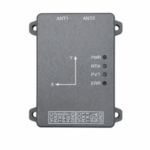
M-2 GNSS Board

The M-2 GNSS Board utilizes the powerful Septentrio Mosaic-X5 module to deliver accurate and reliable positioning data for UAVs, robotics, and other applications. Our GNSS board can easily integrate with a variety of systems. It is an ideal choice for developers and manufacturers seeking high quality GNSS solutions in their related fields.

Category

Description

The M-2 GNSS Board integrates the advanced Septentrio Mosaic-X5 module, offering high-precision GNSS capabilities for a wide range of applications. Whether used in UAVs, robotics, autonomous vehicles, or other precision navigation tasks, the M-2 GNSS Board ensures accurate and reliable positioning data. It supports multi-GNSS constellations including GPS, GLONASS, Galileo, and BeiDou, making it versatile and capable of handling varying environmental conditions. The board features a compact design that is easy to integrate into various systems without compromising performance. The M-2 GNSS Board is an ideal choice for developers and manufacturers seeking high-quality GNSS solutions.

M-2 GNSS Specifications:

  • GNSS Module: Septentrio Mosaic-X5
  • Operating Temperature: -40°C to +85°C
  • Power Supply: 3.3V – 5.5V DC
  • Position Accuracy: <1.5cm (RTK), <5 m (DGPS), <10 m (autonomous)
  • Protocol Support: NMEA, RTCM3, UBX
  • Antenna Connector: U.FL or SMA
  • Dimensions: 40 mm x 40 mm x 6 mm
  • Weight: 20 g

MOSAIC-X5 module features:

  • 31.0 x 31.0 x 4.2 mm LGA package
  • Supports all-constellation multi-frequency on-chip RTK positioning and dual-antenna heading solution
  • Supports GPS L1/L2, BDS B1I/B2I/B3I, GLONASS G1/G2, Galileo E1/E5b and QZSS L1/L2
  • All-system multi-frequency RTK engine and advanced RTK technology
  • AIM+: Industry leading Anti-jamming, Anti-spoofing Interference Monitoring and Mitigation
  • IONO: Advanced protection against ionospheric disturbances to GNSS signals
  • APMEx: a posteriori multipath estimator for code and phase multipath mitigation
  • LOCK+: superior tracking robustness under heavy mechanical shocks or vibration
  • RAIM+: Advanced Receiver Autonomous Integrity Monitoring

Performance Specifications:

Frequency

  • GPS L1C/A, L1PY, L2C, L2P, L5
  • BDS B1I, B1C, B2a, B2b, B2I, B3
  • GLONASS L1CA, L2CA, L2P, L3 CDMA
  • Galileo E1, E5a, E5b, E5 AltBoc, E6
  • QZSS L1C/A, L1C/B, L2C, L5
  • Navic L5
  • SBAS: Egnos, WAAS, GAGAN, MSAS, SDCM (L1,L5)
  • On-module L-band

Single point positioning (RMS):

  • Horizontal: 1.2 m
  • Vertical: 1.9 m
  • Time Precision(xPPS out) – 5 ns
  • Data Update Rate: 100 Hz 

DGPS (RMS):

  • Horizontal: 0.4 m
  • Vertical: 0.7 m
  • Cold start < 45 s
  • Initialization Time < 7 s (typical)
  • Data Update Rate: 100 Hz 

RTK (RMS):

  • Horizontal: 0.6 cm + 0.5 ppm
  • Vertical: 1 cm + 1 ppm
  • Data Update Rate: 100 Hz 
  • Differential Data – RTCM V2.x, V3.X (MSM included), CMR v2.0/CMR+ (input only)
  • Data Format – NMEA-0183, v2.3, v3.03, v4.0, RINEX v2.x, v3.x, Septentrio Binary Format (SBF)

Physical Characteristics:

  • Packaging: 239 pin LGA
  • Dimension: 31.0 × 31.0 × 4.2 mm
  • Weight: 6.8g

Environmental Specifications:

  • Working temperature: -40 °C ~ +85 °C
  • Storage temperature: -55 °C ~ +85°C
  • Humidity: 95% No condensation
  • Vibration: MIL-STD-810G

Communication Interfaces:

  • 4 × UART (3 with hardware flow control)
  • 1 × USB (2.0, HS)
  • 1 × Ethernet (RMII/MDIO), 10/100 Mbps
  • 1 x SD memory card
  • 2 x Event inputs
  • 2 x GPIO
  • 1 x PPS out 

Features of M-2 GNSS Board:

High-precision positioning: It delivers precise and reliable location data for various applications leveragin advanced capabilities using Septentrio Mosaic-X5 GNSS module.

Multi-GNSS constellation support: Ensures flexibility and robustness in navigation by utilizing multiple global navigation satellite systems, ensuring accurate data in diverse enviorments.
Low power consumption: It is manufactured to operate efficiently with low power draw, extending battery life and making it suitable for battery-powered applications such as UAVs and robotics.
Compact design for easy integration: A compact form factor that maintains integration into robotics,UAVs, and other precision navigation devices without compromising performance.
Supports real-time kinematic (RTK) : RTK and DGPS modes provide high-accuracy location, making it perfect for applications that need accurate navigation and data gathering.
Reliable performance in challenging environments: It ensures reliable and consistent location data by optimizing GNSS performance and stability even under challenging circumstances.

Product datasheet

Applications of M-2 GNSS:

Unmanned Aerial Vehicles (UAVs): The M-2 GNSS Board is perfect for UAVs, providing precise navigation and real-time positioning data to ensure safe and efficient flight paths. 

Robotics: In robotics, the M-2 GNSS Board enables accurate navigation and movement control, making it suitable for tasks like automated manufacturing, inspection, and delivery.

Autonomous vehicles: This GNSS board ensures safe navigation and accurate route planning by improving the positioning precision needed for autonomous vehicles even in complex urban environments. 

Surveying and mapping: High-precision positioning data from the M-2 GNSS Board is essential for precise land surveying and in-depth mapping applications.

Precision agriculture: o increase productivity and production, the board provides accurate GNSS data for precision agriculture applications such as field mapping, soil analysis, and crop monitoring. 

Marine navigation: The M-2 GNSS Board provides marine vessels with accurate location data, which is necessary for positioning and safe navigation in offshore or coastal areas. 

Drone delivery systems: The high-precision navigation capabilities of the M-2 GNSS Board are advantageous to this application, guaranteeing that drone delivery systems may arrive at their destinations safely and dependably. 

What is the positioning accuracy of the M-2 GNSS Board?

With an accuracy of less than 1.5 meters (RTK), less than 5 meters (DGPS), and less than 10 meters (autonomous), the M-2 GNSS Board provides high-precision location.

What protocols does the M-2 Board support & operating temperature range?

It supports NMEA, RTCM3, and UBX protocols. The operating temperature range is from -40°C to +85°C. 

What is the M-2 GNSS Board used for?

For surveying, mapping, autonomous systems, and industrial applications needing centimeter-level accuracy, the M-2 GNSS Board offers accurate navigation and location. 

Is the M-2 GNSS Board compatible with other systems?
Absolutely, the M-2 GNSS Board integrates seamlessly with various software platforms and hardware systems, enhancing its flexibility for diverse applications.

How durable is the M-2 GNSS Board in outdoor conditions?

With its durable build that can tolerate high temperatures, dampness, and physical shocks, the M-2 GNSS Board is made for severe settings. 

What connectivity options does the M-2 GNSS Board offer?

The M-2 GNSS Board supports USB, UART, and Bluetooth interfaces, ensuring smooth integration with modern devices for data transfer and analysis.