Experience Pro-Grade Precision with GNSS Solutions Drone GPS — Buy Now

Unmanned aerial vehicles (UAVs, or drones) have transformed industries from aerial photography and surveying to infrastructure inspection and precision agriculture. But every drone pilot knows the weakest link in their system: GPS accuracy. Standard consumer-grade GPS modules drift by several meters, which can ruin survey data, produce unusable 3D models, or even cause collisions. For professional drone operations, centimeter-level GNSS positioning is not a luxury — it is a requirement.
Eview GNSS Solutions builds high-precision GPS modules designed specifically for demanding UAV applications. With multi-band, multi-constellation support and advanced anti-jamming technology, our drone GPS solutions deliver the reliability professionals depend on.
Why Standard GPS Falls Short for Drone Operations
Most consumer drones use single-frequency GPS modules that provide 2–5 meter accuracy under ideal conditions. In real-world environments — near buildings, under tree cover, or during atmospheric disturbances — accuracy degrades further. For professional applications, this level of precision simply isnt enough.
- Aerial Surveying and Mapping: Every meter of GPS error translates directly into inaccurate orthomosaics, elevation models, and volumetric measurements
- Infrastructure Inspection: Inspecting power lines, pipelines, or cell towers requires knowing exactly where the drone is relative to the structure
- Precision Agriculture: Variable-rate application, crop scouting, and yield mapping demand sub-meter accuracy to be effective
- Search and Rescue: Reliable positioning can mean the difference between finding a target and missing it entirely
What Makes a Professional Drone GPS Different
Eview GNSS drone GPS modules are engineered for the real-world conditions that professional drone operators face. Here is what sets them apart from consumer-grade alternatives:
Multi-Band, Multi-Constellation Tracking
Professional GNSS modules track signals from GPS, GLONASS, Galileo, and BeiDou across multiple frequency bands (L1, L2, L5). This provides:
- Faster satellite acquisition and more reliable positioning in challenging environments
- Resilience against signal loss when flying near structures or in valleys
- Better accuracy by using additional frequency measurements to correct atmospheric errors
RTK and PPP Correction Support
For applications requiring centimeter-level accuracy, Eview GNSS modules support Real-Time Kinematic (RTK) corrections. An RTK-enabled drone can achieve 1–2 cm accuracy in real time by receiving correction data from a base station or NTRIP network. This is essential for precision mapping, automated flight paths, and landing zone accuracy.
Advanced Anti-Jamming (AIM+) Technology
Radio frequency interference is a growing problem in urban and industrial environments. Eview GNSS receivers feature advanced interference mitigation technology that filters out jamming signals, ensuring reliable positioning even in challenging RF environments. This is a critical advantage over standard GPS modules that can lose lock entirely when interference is present.
Key Applications for High-Precision Drone GPS
Surveying and Mapping
Survey-grade drones equipped with RTK GNSS modules eliminate the need for ground control points (GCPs) in many mapping workflows. With centimeter-level accuracy direct from the drone, surveyors can produce accurate orthophotos, digital elevation models, and 3D point clouds faster and with less ground work.
Precision Agriculture
Farmers and agronomists rely on accurate drone positioning for crop health mapping, variable-rate application, and field boundary delineation. Consistent sub-meter accuracy ensures that multi-temporal imagery aligns perfectly, enabling accurate change detection throughout the growing season.
Infrastructure and Industrial Inspection
Inspecting bridges, power lines, pipelines, and cell towers requires precise positioning to document asset locations and identify defects. High-precision GNSS ensures that inspection data is georeferenced accurately for integration with asset management systems.
Autonomous Drone Operations
For beyond-visual-line-of-sight (BVLOS) operations and autonomous drone-in-a-box systems, reliable GNSS positioning is foundational. Eview GNSS modules provide the stable, centimeter-accurate position data that autonomous flight controllers need for safe navigation, precision landing, and return-to-home functions.
Eview GNSS Drone GPS Solutions
Eview GNSS offers a range of products suitable for drone integration:
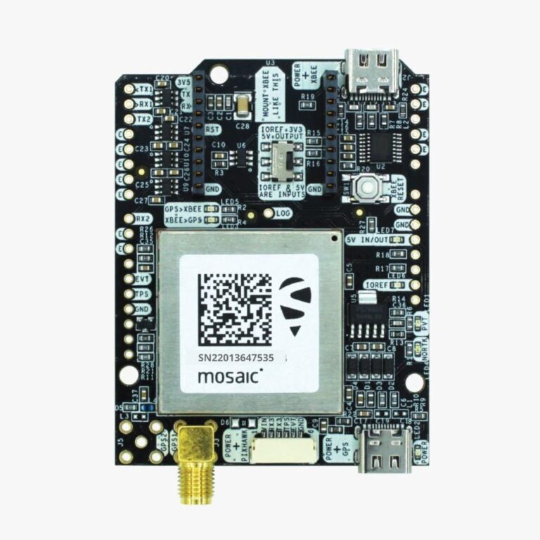
- GNSS Board Modules — Compact, lightweight boards that integrate directly with Pixhawk, ArduPilot, and other flight controllers. Ideal for custom drone builds and OEM integration.
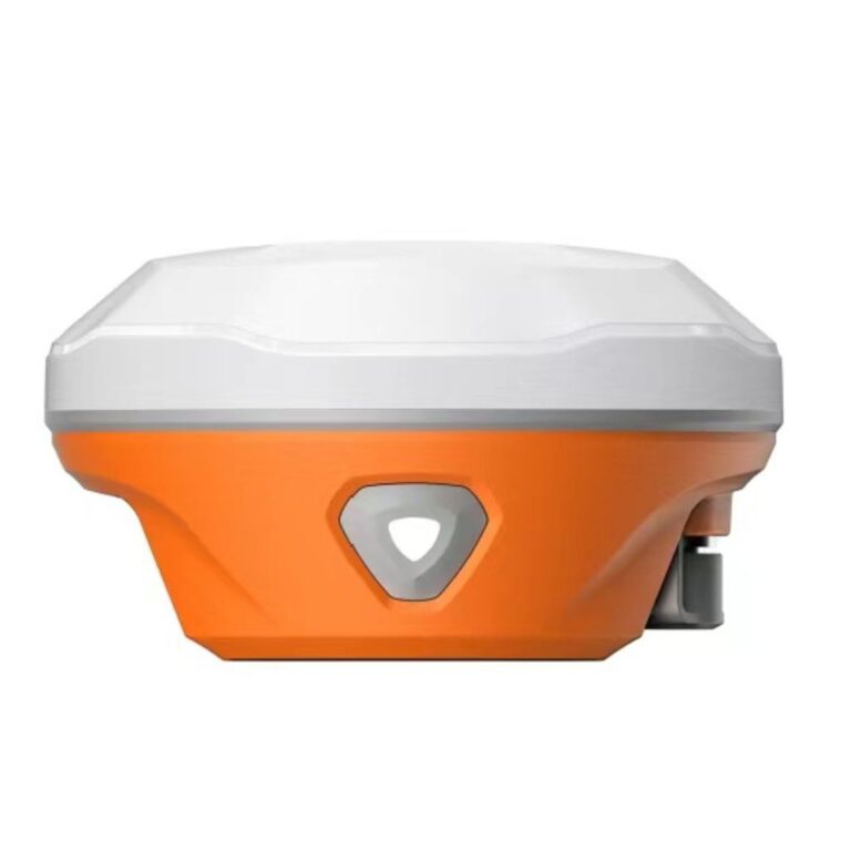
- RB3 AsteRx-m3 Pro+ — A rugged multi-frequency receiver with AIM+ anti-jamming, suitable for ground stations, base stations, and Rovers used in drone survey workflows.
- UAV GNSS Applications — Learn more about how our GNSS technology is deployed in drone operations across different industries.
Getting Started
Upgrading your drone from consumer-grade GPS to professional GNSS positioning is one of the highest-impact improvements you can make. Whether you are building a custom drone, upgrading an existing platform, or designing a new UAV system, Eview GNSS has the modules and expertise to help you achieve the accuracy your application demands.
Contact us to discuss your requirements or browse our product range to find the right GNSS solution for your drone platform.
Frequently Asked Questions About Professional Drone GPS
What is the difference between consumer GPS and professional drone GNSS?
Consumer GPS provides 2–5 meter accuracy. Professional GNSS modules use multi-band, multi-constellation tracking with RTK for 1–2 cm accuracy and include anti-jamming technology for reliable operation.
Can I upgrade my drone to RTK GNSS?
Yes. Most flight controllers accept external GNSS modules via UART. You can replace the stock GPS module with an RTK-capable GNSS board for centimeter-level accuracy.
Does RTK work beyond visual line of sight?
RTK corrections require a data link. NTRIP corrections over 4G/LTE provide the best coverage for BVLOS operations. PPP is an alternative option for long-range flights.
What is AIM+ anti-jamming in GNSS receivers?
AIM+ is Eview’s advanced interference mitigation technology providing 60 dB of jamming signal rejection, ensuring reliable positioning near radio transmitters or power infrastructure.