Galileo HAS: Free Satellite-Based PPP — Technology Guide and Mosaic-G5 P3H Field Results
Galileo’s High Accuracy Service (HAS) is the first high-accuracy correction service broadcast for free by a GNSS constellation itself. Corrections travel over the Galileo E6-B signal — and over the internet in parallel — so a compatible receiver can reach decimeter-level real-time positioning without a base station, without a CORS network and without a subscription. This guide explains what HAS is, how the service is evolving toward full operational capability, which Septentrio Mosaic-G5 modules appear on the official GSC support list, how to enable HAS on a receiver, and what a Mosaic-G5 P3H actually measured in the field: 10 cm accuracy in open sky.
1. What Is Galileo HAS?
Galileo High Accuracy Service (HAS) is a free high-accuracy service offered by the Galileo system in addition to its Open Service. It delivers, over two channels — the Galileo E6-B signal and terrestrial internet distribution — the correction information a receiver needs to compute real-time Precise Point Positioning (PPP) solutions at high accuracy.
HAS is a correction data service, not a ready-made position: after the receiver receives the corrections, its internal PPP algorithm has to solve them to obtain a high-accuracy PVT solution.
The initial HAS service (declared on 24 January 2023) provides:
- satellite orbit corrections referred to the broadcast ephemeris;
- satellite clock corrections referred to the broadcast ephemeris;
- satellite biases — code biases (phase biases will follow in a later service evolution).
Supported constellations and signals:
- Galileo: E1 / E5a / E5b / E6 signals corresponding to the I/NAV navigation message;
- GPS: L1 / L2C signals corresponding to the LNAV navigation message;
- Future evolutions will add phase biases and extend to Galileo E5 AltBOC and GPS L5.
2. Service Evolution: From Initial Service to Full Operational Capability
Galileo HAS follows a phased deployment roadmap:
- Phase 0 (2020–2022): a series of tests and user trials before the formal service, used to finalise the service definition;
- Phase 1 (from 24 January 2023): declaration and operation of the HAS initial service;
- Phase 2: evolution to Full Operational Capability (FOC), reaching the SL1 target performance and providing the SL2 service level.
Note that the initial service provides a reduced version of SL1 — with reduced coverage and performance relative to the full-service targets — and does not yet provide phase biases.
3. Service Levels and Official Target Performance (SL1 / SL2)
The full HAS service will provide two service levels with the following official target parameters:
| Item | Service Level 1 (SL1) | Service Level 2 (SL2) |
|---|---|---|
| Service area | Global coverage | Regional: European Coverage Area (ECA) — the 27 EU member states, Norway, Switzerland and adjacent sea/airspace |
| Correction products | Orbit and clock corrections, code and phase biases | All SL1 products + atmospheric corrections |
| Distribution | HAS SIS (E6-B) + HAS IDD (internet) | HAS SIS (E6-B) + HAS IDD (internet) |
| Accuracy target (95%) | 20 cm horizontal / 40 cm vertical | 20 cm horizontal / 40 cm vertical |
| Availability target | 99% | 99% |
| Convergence time target | 300 seconds | 100 seconds |
Note: the table above shows full-service (Full Service) targets. Today the service runs as the reduced SL1 version; SL2 belongs to Phase 2 Full Operational Capability.
4. Typical Positioning Performance (Reference Data, Not a Service Commitment)
Appendix E of the Service Definition Document gives the typical positioning performance a HAS user can achieve (based on the official performance characterisation algorithm, assuming open sky, a static user and an average user position inside the service area):
| Metric | Galileo only (≥5 valid correction satellites) | Galileo + GPS (≥8 valid correction satellites) |
|---|---|---|
| Horizontal accuracy (68%, any 24 hours) | ≤ 25 cm | ≤ 15 cm |
| Vertical accuracy (68%, any 24 hours) | ≤ 30 cm | ≤ 20 cm |
| Availability (30-day statistics) | ≥ 90% | ≥ 90% |
Note: these are officially published, indicative values and do not constitute a service commitment. Real-world accuracy varies with the number of visible satellites, sky obstruction and the quality of the receiver’s PPP algorithm.
5. Service Architecture: How HAS Corrections Are Generated and Distributed
- The High Accuracy Data Generator (HADG) receives data from Galileo Sensor Stations (GSS) and produces high-accuracy corrections for Galileo and GPS.
- The Galileo ground core infrastructure merges the corrections into a single data stream at 448 bit/s per satellite.
- The stream is uplinked through Uplink Stations (ULS) to the Galileo satellites, which broadcast it in the E6-B signal component.
- The same correction data is distributed simultaneously over the terrestrial internet link (HAS IDD).
- The user receiver applies the corrections and solves PPP to obtain a high-accuracy position.
Both channels carry identical content and act as redundant complements of each other; users can choose one or use both at the same time.
6. Two Ways to Receive HAS Corrections
6.1 Method One — Space Signal (HAS SIS via E6-B)
HAS corrections are received in the Galileo E6-B data component: no registration is required and the service is free to use. The receiver must be able to track the E6 frequency (1278.75 MHz) and decode the HAS data in E6-B. The detailed signal format is described in the Galileo HAS Signal-in-Space Interface Control Document (HAS SIS ICD).
6.2 Method Two — Internet Data Distribution (HAS IDD)
HAS IDD is based on the NTRIP protocol (NTRIP v2, with HTTP and optional TLS encryption) and distributes data encoded in RTCM v3. NTRIP is the de-facto standard for real-time terrestrial GNSS data distribution and is supported by the vast majority of professional receivers.
IDD access requires (free) registration authorisation. The official process is:
- Register a user account on the GSC website (skip if you are already a registered user);
- Complete and submit the HAS IDD access request form (accepting the terms of service);
- After EUSPA authorisation, a confirmation e-mail with access instructions arrives at the registered address;
- Connect to the HAS NTRIP Caster as instructed (credentials are provided after successful registration).
The NTRIP client can be implemented inside the receiver or run as external software (for example the open-source BKG Ntrip Client). The exact interface definition is in the HAS IDD Interface Control Document (IDD ICD), available to registered users.
7. Septentrio Receivers Listed for Galileo HAS
Several models of the Septentrio Mosaic-G5 family appear on the GSC’s official “receivers supporting Galileo HAS” list (HAS channel: E6B):
| Model | Target application (GSC list) | HAS channel |
|---|---|---|
| Septentrio Mosaic-G5 P3 | UAVs, robotics | E6B |
| Septentrio Mosaic-G5 P3H | UAVs, robotics | E6B |
| Septentrio Mosaic-G5 T | Timing and synchronisation, critical infrastructure | E6B |
| Septentrio Mosaic-G5 P6 | Survey and construction, industrial automation, UAVs | E6B |
| Septentrio Mosaic-G5 P8 | APNT, rail, maritime, mission-critical operations | E6B |
Note: the GSC list is compiled from information vendors declare publicly; inclusion in the list is not a certification.
Survey, construction, machine-control and uncrewed-system applications built on these receivers can obtain satellite-based PPP corrections free of charge over the Galileo E6-B signal, reaching decimeter-level positioning in areas without CORS coverage or where setting up a base station is impractical.
8. How to Enable Galileo HAS on a Septentrio Receiver
This section applies to Septentrio receivers with the PPPGalileoHAS feature.
- Antenna requirement: make sure the receiver is connected to an antenna that supports the E6 band (covering 1278.75 MHz).
- Enable E6-B tracking and data usage: confirm that GALE6BC tracking is enabled and that use of its navigation data (including PPP corrections) is enabled — normally the default. If not enabled, turn it on with:
setSignalTracking, +GALE6BC <CR>setSignalUsage, ,+GALE6BC <CR> - Automatic decoding and application: the receiver automatically decodes and applies the PPP corrections received from the Galileo E6 signal. Note that reaching decimeter-level accuracy may take several minutes of convergence.
- Verify the positioning mode: in Galileo HAS mode, the Mode field of the PVTCartesian and PVTGeodetic SBF blocks reports the positioning mode “PPP”, and the TimeSystem field reports Galileo time.
9. Galileo HAS vs BeiDou PPP-B2b
The other free satellite-based PPP service in the same class as Galileo HAS is China’s BeiDou PPP-B2b. Both follow the same model — the system broadcasts corrections and the user receiver solves PPP — with the main differences in service area and signal design:
| Item | Galileo HAS (EU) | BeiDou PPP-B2b (China) |
|---|---|---|
| Service operator | EU Galileo system (EUSPA / European Commission) | China’s BeiDou Navigation Satellite System |
| Cost | Free | Open and free |
| Distribution | Dual channel: E6-B satellite broadcast + internet (IDD / NTRIP) | Satellite broadcast (BeiDou GEO, B2b signal) |
| Broadcast rate | 448 bit/s per satellite (E6-B) | 500 bit/s (B2b) |
| Service area | SL1 targets global coverage, phased per the official roadmap | China and surrounding regions; measured availability above 80% in China and broadly above 70% across Asia |
| Correction content | Orbit/clock corrections and code biases (phase biases not yet in the initial service) | Orbit, clock and code-bias corrections |
| Corrected constellations | Galileo + GPS | Primarily BeiDou; multi-constellation expansion planned |
| Accuracy | Official target (95%): 20 cm horizontal / 40 cm vertical; typical (68%): ≤25/30 cm Galileo-only, ≤15/20 cm Galileo+GPS | Official: real-time decimeter level; published studies: centimetre level static, decimeter level kinematic |
| Convergence time | SL1 target 300 s; SL2 target 100 s | — |
| Receiver requirements | E6-B decoding + PPP algorithm (e.g. Septentrio Mosaic-G5 family, see section 7) | B2b signal reception/decoding + PPP algorithm (supported models per vendor documentation) |
Note: HAS data is taken from the GSC website and the Galileo HAS Service Definition Document (v1.0); PPP-B2b data is taken from official Chinese releases and public academic assessments (Guo Fei et al., Journal of Nanjing University of Information Science and Technology, 2022).
10. Mosaic-G5 P3H HAS Field Results: 10 cm in Open Sky
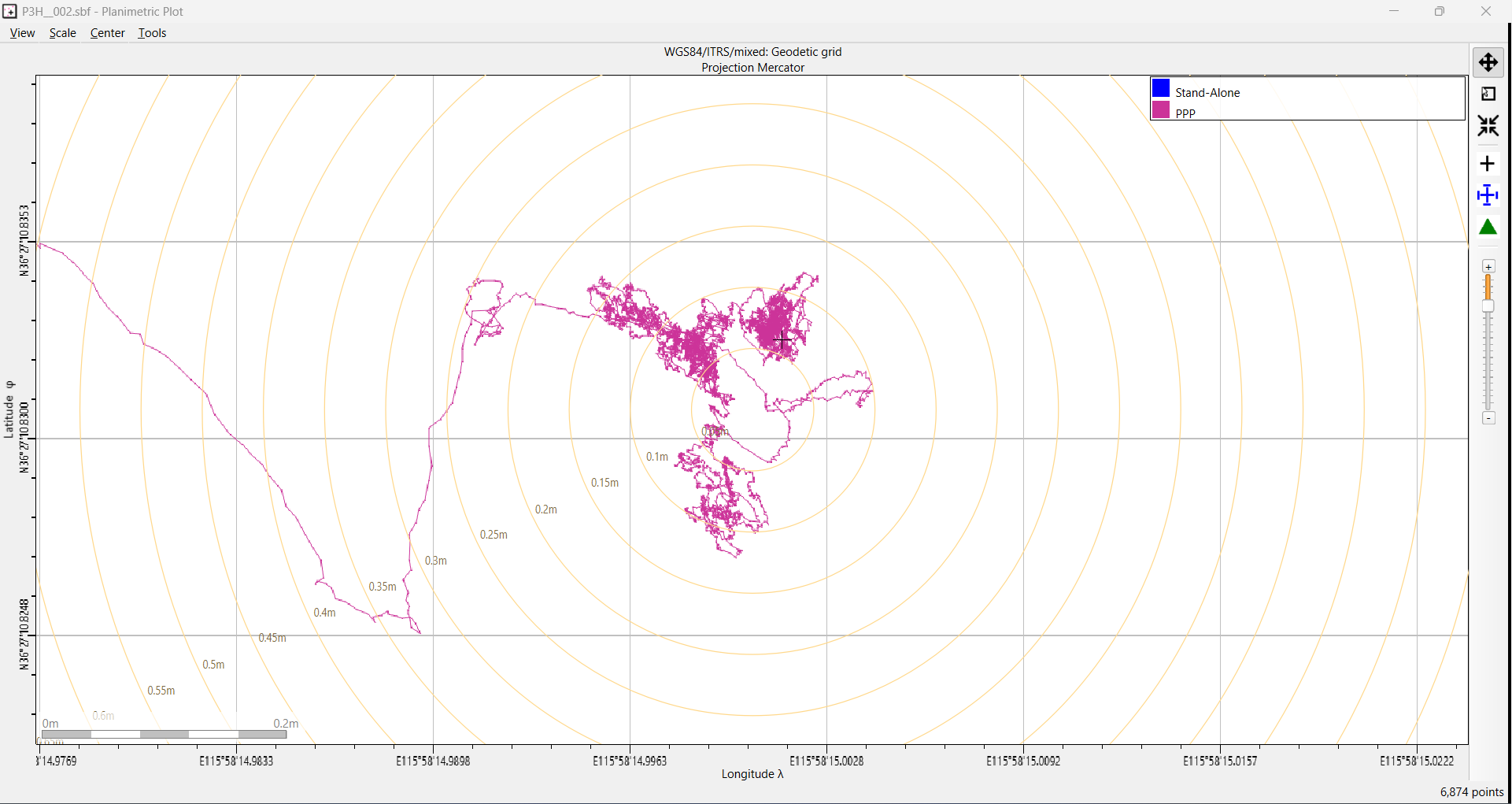
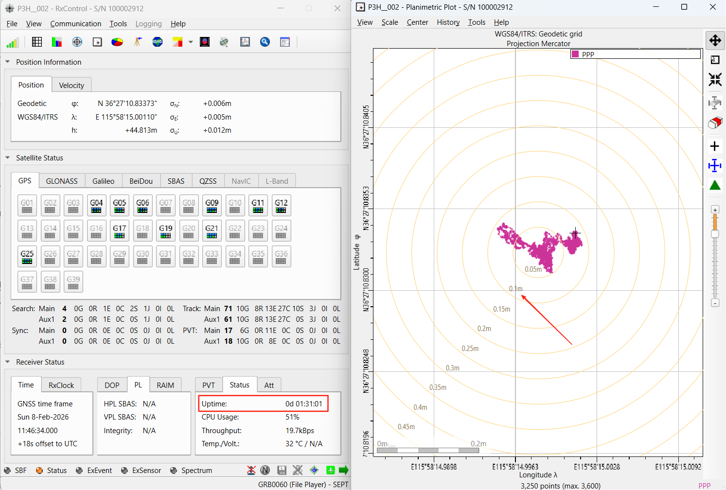
This section reports what a Septentrio Mosaic-G5 P3H measured with Galileo HAS: in an open, unobstructed environment, HAS PPP positioning accuracy reached 10 cm.
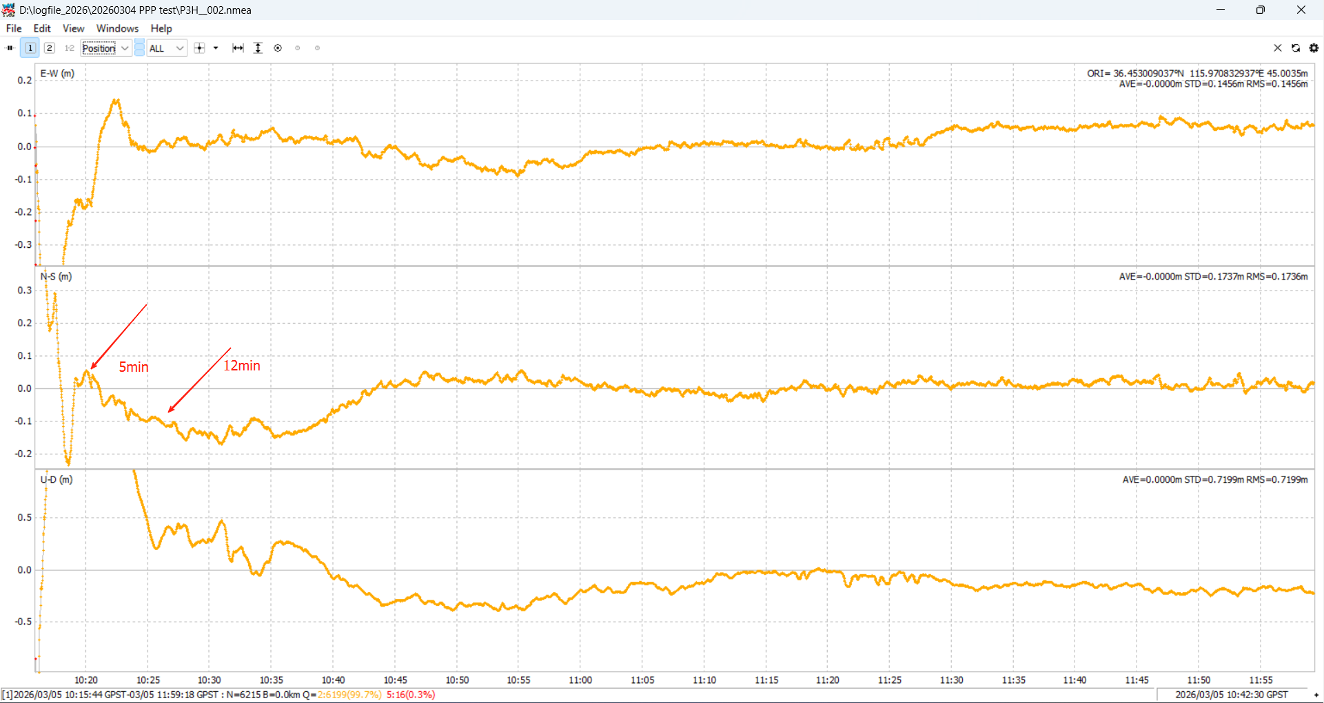
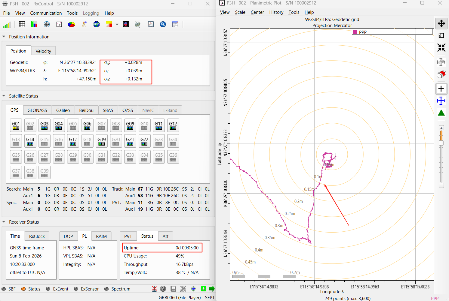
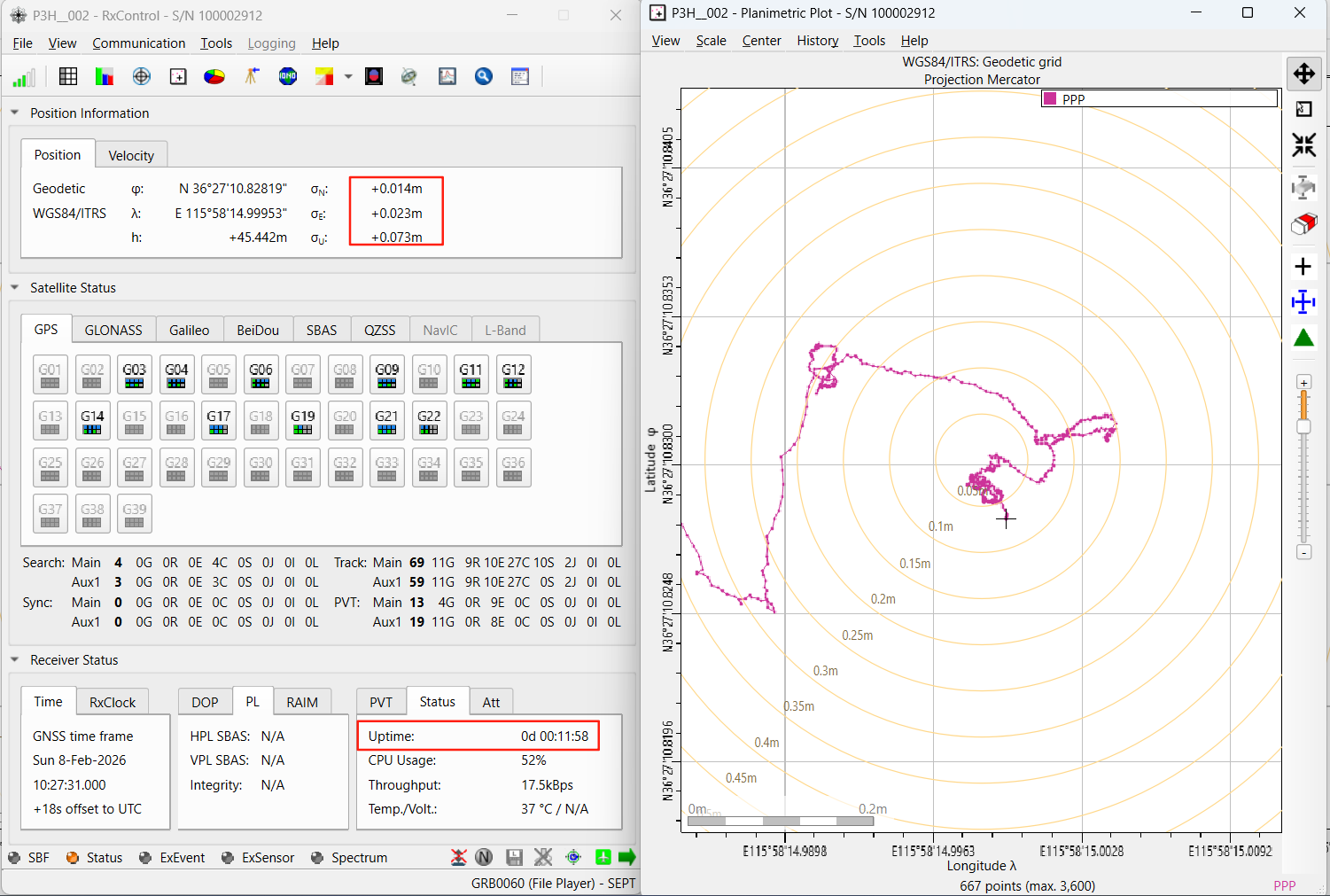
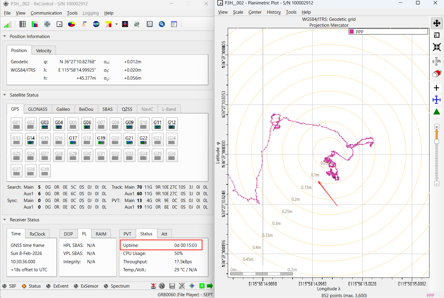
Test objective: measure HAS PPP positioning accuracy and convergence time. Counted from power-on, roughly 5 minutes were needed to reach 20 cm accuracy and roughly 12 minutes to reach 10 cm.
Test setup:
- Equipment: survey antenna (P100), signal splitter, cabling, and receivers (Mosaic-G5 P3H and Mosaic-G5 P6);
- Firmware: Mosaic-G5P3 1.1.0-beta1, Mosaic-G5P6 1.1.0-beta1;
- Environment: open, unobstructed outdoor area with the antenna on a rooftop, an RF splitter feeding both receivers simultaneously;
- Duration: about 2 hours, from 10:16 to 12:10;
- PPP setting:
setPVTMode, , StandAlone+DGNSS+RTKFixed+PPP.
Results: HAS PPP accuracy reached 10 cm. Counted from power-on, roughly 5 minutes were needed for 20 cm and roughly 12 minutes for 10 cm. With HAS active, the Mosaic-G5 used 11–17 satellites in a GPS + Galileo dual-constellation setup (about 4 GPS and 9 Galileo).
The test logs (P3H__002.sbf, P3H__002.nmea) are analysed below:
Note: the measurements above were taken with a Mosaic-G5 P3H in a specific test environment and are given for illustration only; they do not constitute a service commitment. Actual accuracy varies with the number of visible satellites, sky obstruction and the quality of the receiver’s PPP algorithm.
11. References
- GSC-Europa: Galileo High Accuracy Service (HAS), Galileo HAS Internet Data Distribution and the list of receivers supporting HAS (www.gsc-europa.eu, accessed September 2026)
- European Union: Galileo HAS Service Definition Document, Issue 1.0, January 2023
- Galileo HAS Signal-in-Space Interface Control Document (HAS SIS ICD), published by GSC
- Galileo HAS Internet Data Distribution Interface Control Document (IDD ICD), available to registered users
- Guo Fei et al.: Signal accuracy and precise point positioning performance assessment of BeiDou-3 PPP-B2b, Journal of Nanjing University of Information Science and Technology, 2022 (DOI: 10.13878/j.cnki.jnuist.2022.06.003)
- Official BeiDou PPP-B2b service releases (China Satellite Navigation Office / BeiDou website)
- Septentrio receiver documentation (Galileo HAS configuration chapter)
Note: the data in this article is compiled from the GSC website (accessed September 2026) and the Galileo HAS Service Definition Document Issue 1.0 (January 2023); for the latest HAS service status, always check the GSC service notices.
12. Frequently Asked Questions
Is Galileo HAS free, and do I need a subscription?
Galileo HAS is completely free. Receiving corrections through the Galileo E6-B signal in space needs no registration and no subscription; internet distribution (HAS IDD) is equally free and only requires a one-off free registration and authorisation through the GSC.
Do I need my own base station or CORS coverage to use HAS?
No. HAS is a satellite-based PPP correction service: corrections are broadcast by the Galileo satellites in the E6-B signal, or distributed over the internet as an NTRIP (RTCM v3) stream. No base station and no CORS network coverage is required.
Does HAS give me a high-accuracy position directly?
Not directly. HAS provides orbit, clock and code-bias corrections; the receiver has to solve them with its internal PPP algorithm to obtain a high-accuracy PVT solution. In Galileo HAS mode, the Mode field of the PVTCartesian and PVTGeodetic SBF blocks reports “PPP”.
Which Septentrio receivers support Galileo HAS?
On the GSC’s official list, the Septentrio Mosaic-G5 P3, P3H, T, P6 and P8 are all included, with E6B as the HAS channel. The receiver needs the PPPGalileoHAS feature and an antenna covering the E6 band at 1278.75 MHz.
What accuracy and convergence time did the Mosaic-G5 P3H measure?
In open sky, HAS PPP accuracy reached 10 cm; from power-on it took about 5 minutes to reach 20 cm and about 12 minutes to reach 10 cm. With HAS active the receiver used 11–17 satellites in a GPS + Galileo combination (about 4 GPS and 9 Galileo).
How does Galileo HAS differ from BeiDou PPP-B2b?
Both are free satellite-based PPP services that broadcast corrections and let the receiver solve PPP. HAS is operated by the EU Galileo system and uses a dual channel (E6-B broadcast plus internet IDD), correcting Galileo and GPS; BeiDou PPP-B2b is operated by the BeiDou system, broadcast over GEO satellite B2b signals, and currently serves China and surrounding regions with BeiDou as the primary constellation.
Sources & References
Author: Eview GNSS engineering team · Published: September 10, 2026 · Source document: Galileo HAS technology and application brief v1.1 (including Mosaic-G5 P3H test results) · External references: GSC-Europa, Galileo HAS Service Definition Document Issue 1.0 (January 2023). Septentrio world wide largest dealer ‑ Nanjing Hongcheng. Field measurements were taken with a Mosaic-G5 P3H in a specific test environment and are illustrative only.
Related Reading
- Galileo HAS Technology and Application Brief, with Mosaic-G5 P3H results (Chinese version, gnss-imu.com)
- Galileo HAS on Mosaic-G5 P3H: Measured 10 cm Accuracy for Drone Operations (uav-gnss.com)
- Which GNSS Receiver Supports RTK and PPP? A Complete Technical Guide (gnss-solutions.com)
- Septentrio mosaic-X5 vs mosaic-G5 P3H: What Is the Difference? (gnss-solutions.com)
Eview GNSS supplies the Septentrio Mosaic-G5 P3, P3H, P6 and mosaic-X5 receivers and modules with E6-capable antennas for Galileo HAS, RTK and PPP workflows — Septentrio world wide largest dealer ‑ Nanjing Hongcheng. Email tina.ng@gnss-solutions.com for a quote or a technical consultation on Galileo HAS integration.