Port Logistics Positioning That Survives Steel: a Straddle Carrier GNSS Receiver Re-Engineered on Septentrio mosaic-X5

At a glance
| Item | Detail |
|---|---|
| Customer | Port of Antwerp (PSA Antwerp) |
| Industry / scenario | Port · container terminal straddle carrier operations |
| Application | Real-time straddle carrier positioning and container movement tracking |
| Product | Straddle Carrier GNSS Receiver (SCGR unit) |
| Core technology | Septentrio mosaic-X5 GNSS module |
| Cooperation model | Custom design, development and delivery by MGB-Tech |
| Delivery time | Re-engineered in under three months, no operational downtime |
PSA Antwerp operates straddle carriers in a demanding container-terminal environment where reliable positioning is essential for continuous logistics. This case uses a customized Straddle Carrier GNSS Receiver, or SCGR, based on Septentrio mosaic-X5 technology. The system supports real-time straddle-carrier positioning and container movement tracking, and the re-customized solution was delivered in under three months without interrupting operations.

Figure 1 — Container cranes at the MSC PSA European Terminal (MPET), Port of Antwerp.
Why a port is hard on GNSS
Port environments are especially difficult for GNSS. Large metal structures, stacked containers, cranes, and moving equipment can block satellite signals and create severe reflections. These effects can reduce positioning quality and availability. For container logistics, reliable positioning is critical because each container must be located accurately while operations continue without interruption. The solution therefore needs centimeter-level RTK accuracy and update rates of up to one hundred hertz.
The challenge, quantified from publicly verifiable information only:
| Metric | Value / note | Source |
|---|---|---|
| Port scale | Port of Antwerp container throughput of roughly 8.6 million TEU (year per the latest official public figure) | Antwerp Port Authority (public) |
| Accuracy requirement | Centimetre-level (RTK) | Septentrio public product documentation |
| Update rate | Up to 100 Hz | Septentrio public product documentation |
| Number of carriers / downtime cost / cost of error | Not disclosed publicly; to be supplied by the project owner if cited | — |
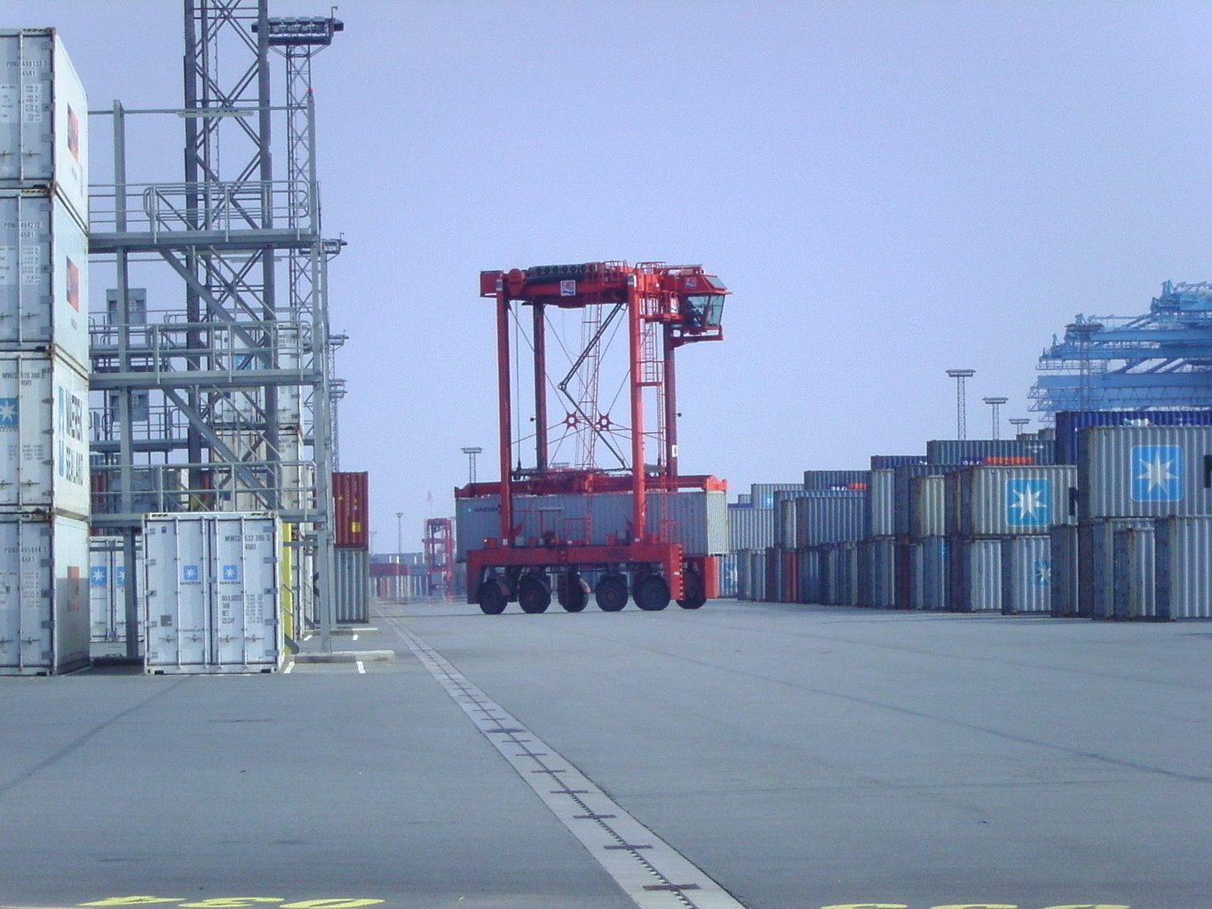
Figure 2 — A straddle carrier working a container terminal yard.
The solution: system architecture and data flow
The system connects positioning, vehicle events, and backend management in one real-time workflow. A GNSS antenna receives multi-frequency, multi-constellation satellite signals. The SCGR receiver, based on Septentrio mosaic-X5, generates centimeter-level positioning. Sensors on the straddle carrier detect each loading and unloading event. Position and event data are then transmitted through Ethernet or serial interfaces using standard formats such as NMEA and RTCM. The client backend receives this information for continuous container tracking, scheduling, and operational management.
- GNSS antenna — receives multi-frequency, multi-constellation satellite signals (L-band, RF interface).
- SCGR receiver — built on the Septentrio mosaic-X5 module and outputting centimetre-level positioning.
- Straddle carrier sensors — detect every container load and unload event.
- Data transmission — sent over Ethernet (ETH) or serial (SER) in standard formats such as NMEA and RTCM.
- Client back-end system — receives the precise position of each container for continuous monitoring, dispatching and efficient management.
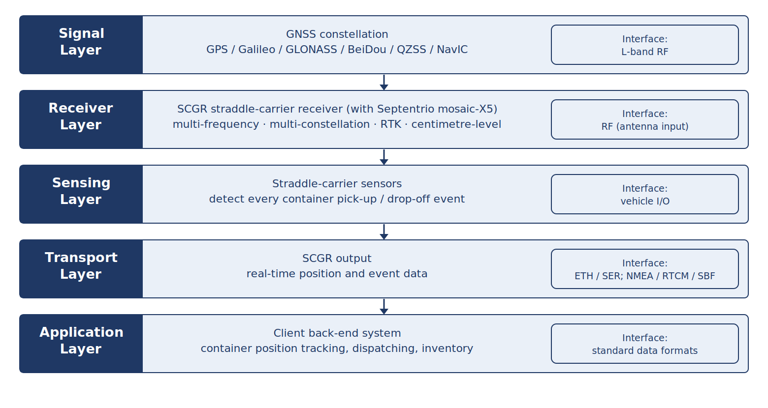
Figure 3 — System architecture: signal layer to application layer.
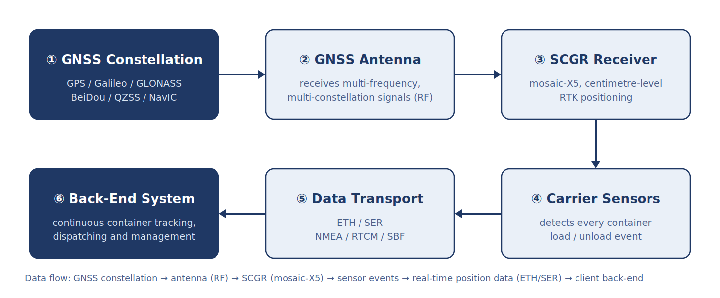
Figure 4 — Data flow: GNSS constellation, antenna (RF), SCGR (mosaic-X5), sensor load/unload events, real-time position data (ETH/SER), client back-end system.
Figure 5 — PSA Antwerp container terminal: straddle carriers moving containers in the yard aisles. Image courtesy of PSA Antwerp.
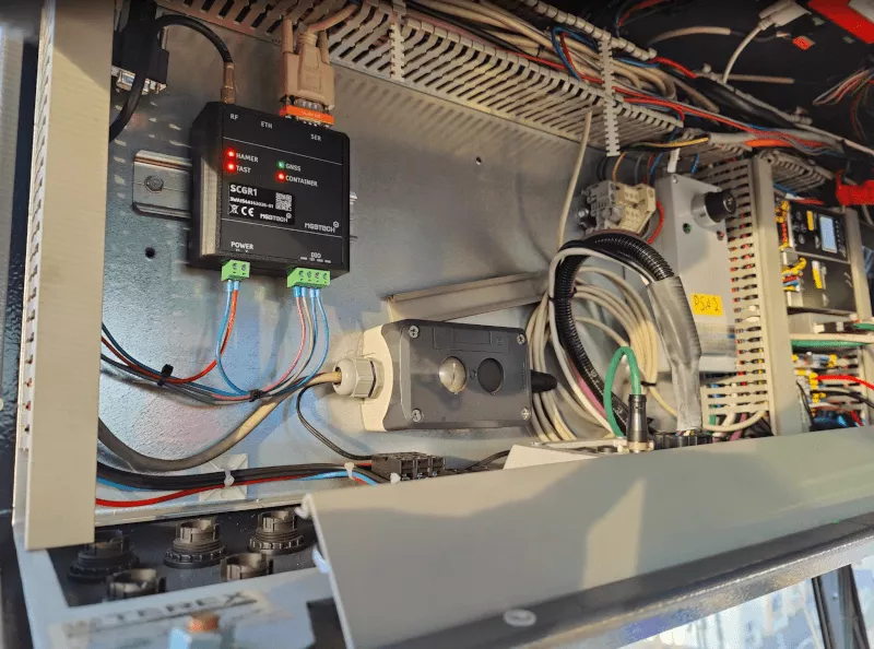
Figure 6 — The SCGR1 receiver (FemtoTec) installed in a straddle carrier electrical control box, showing the POWER / FAST / GNSS / CONTAINER indicators and the RF / ETH / SER interfaces.
Why this technology stack
The solution combines several GNSS technologies designed for harsh operating conditions. Multi-frequency and multi-constellation tracking improves satellite availability. APME+ helps reduce multipath effects caused by containers, cranes, and other metal structures. LOCK+ supports continuous satellite tracking during shock and vibration. AIM+ provides interference and spoofing protection, while IONO+ and RAIM+ support long-term reliability and integrity monitoring. With centimeter-level RTK positioning and update rates up to one hundred hertz, the platform can support real-time control and automated port operations.
| Technology / capability | What it does in a port |
|---|---|
| Multi-frequency, multi-constellation GNSS | Tracks GPS, Galileo, GLONASS, BeiDou, QZSS and NavIC simultaneously, raising visible-satellite count and positioning availability. |
| APME+ multipath suppression | Separates the direct signal from reflections produced by containers, cranes and large steel structures, improving positioning quality. |
| LOCK+ vibration-robust tracking | Adjusts parameters automatically during impact and heavy vibration, so satellite tracking is not lost. |
| AIM+ anti-jamming / anti-spoofing | Suppresses narrowband, wideband and pulsed interference and adds spoofing protection for stable operation in complex electromagnetic environments. |
| IONO+ / RAIM+ | Ionospheric disturbance protection plus receiver autonomous integrity monitoring for long-term reliability and safety. |
| 100 Hz update rate with centimetre-level RTK | Meets the high refresh rate and low latency that automation and real-time control demand. |
| Compact, ultra-low power | The module measures 31 × 31 × 4 mm and weighs under 7 g, so it integrates easily into vehicle-mounted equipment. |
Why MGB-Tech
- Long-term partner — MGB-Tech is a long-standing Septentrio partner with deep experience in GNSS-based positioning solutions.
- Customisation — as positioning and measurement specialists, MGB-Tech delivers tailored solutions and develops dedicated hardware for the customer’s scenario.
- Fast delivery — the re-engineered product was delivered in under three months.
- Business continuity — the upgrade kept PSA Antwerp’s operation running while holding reliable positioning performance.
- Breadth of product line — GNSS equipment, PPS/NMEA signal distributors and machine guidance.
- Industry coverage — surveying, construction and maritime markets where accuracy requirements are strict.
Delivery and implementation
The full cycle took under three months and never stopped terminal operations:
- Requirement review — mapping the functions and field constraints of the existing SCGR units.
- Re-design — redesigning the product around the Septentrio mosaic-X5 module.
- Verification and testing — confirming that every function was preserved and that port requirements were met.
- Switch-over — remaining compatible with the client’s existing back-end system for a seamless replacement.
Results
- Continuous monitoring — real-time visibility of straddle carrier and container movement.
- Efficient management — load/unload event detection plus live position feedback feeding dispatch and inventory systems.
- No business interruption — the terminal kept operating throughout the upgrade.
- Publicly quotable figures — centimetre-level RTK accuracy, update rate of up to 100 Hz, and an uninterrupted operation.
Eview receivers that do the same job — Septentrio Inside
For similar applications, Eview offers GNSS receivers using Septentrio Inside technology. The HBEV322 and HBEV322H are compact RTK receivers based on the mosaic-G5 P3H platform, supporting centimeter-level positioning and dual-antenna heading. The HB50, HB56, HB50H, and HB56H series also provide multi-frequency, multi-constellation GNSS and centimeter-level RTK performance. HB50 and HB56 support update rates up to one hundred hertz. These products can be used as complementary or alternative solutions for port vehicles, AGVs, robotics, UAVs, and other applications requiring robust high-accuracy positioning.
HBEV322 / HBEV322H — compact RTK GNSS receiver, Septentrio mosaic-G5 P3H inside (built-in compass)
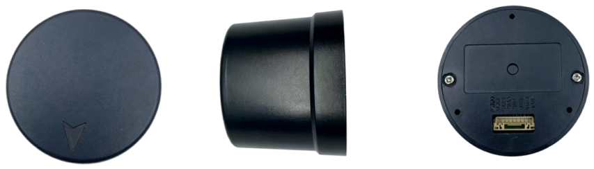
Figure 7 — HBEV322 / HBEV322H product images (top, side and bottom views). Source: Eview GNSS HBEV322 / HBEV322H documentation.
- Positioning — built on the Septentrio mosaic-G5 P3H module with 789 simultaneous tracking channels and support for GPS / BDS / GLONASS / Galileo / QZSS; RTK accuracy of 0.6 cm + 0.5 ppm horizontally and 1 cm + 1 ppm vertically.
- Heading and attitude — dual-antenna heading with 0.15° heading accuracy at a 1 m baseline and 0.25° roll/pitch, plus a built-in QMC5883L electronic compass for direction data on straddle carriers and AGVs.
- Interference and multipath — AIM+, APME+, LOCK+ and IONO+ cover anti-jamming / anti-spoofing, multipath suppression, continuous tracking under strong vibration and ionospheric scintillation protection.
- Update rate and interface — 1–20 Hz data update (1 Hz default), NMEA 0183 and RTCM v3.x output, 8-pin GH1.25 connector.
- Size and power — φ44 × 40.6 mm, 14 g, power consumption below 800 mW — suited to compact platforms.
HB50 / HB56 / HB50H / HB56H — multi-frequency RTK GNSS receivers, Septentrio Inside
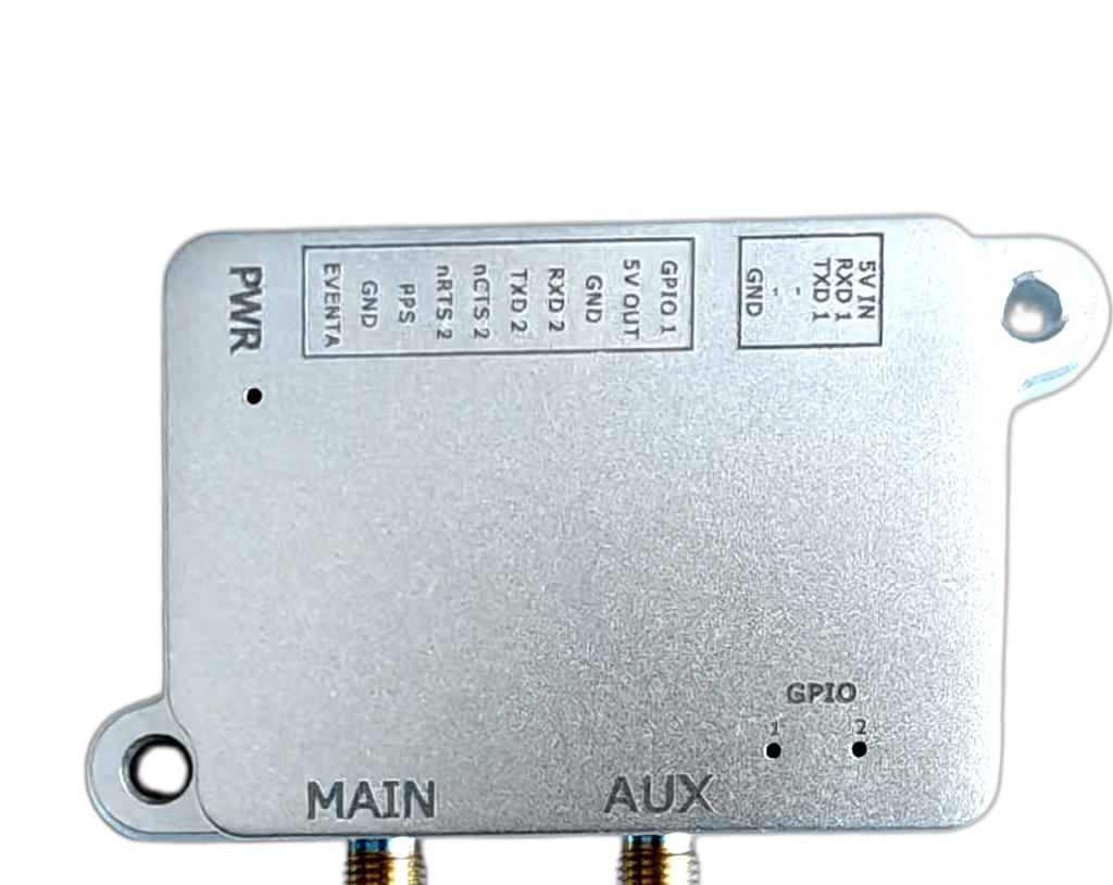
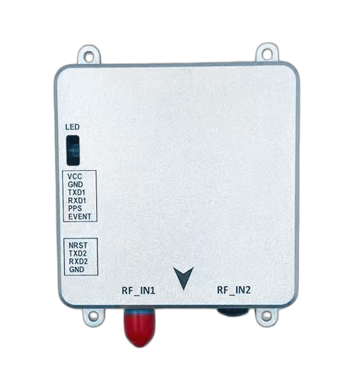
Figure 8 — HB50 / HB56 (left) and HB50H / HB56H (right) product images. Source: Eview GNSS HB50 / HB56 / HB50H / HB56H documentation.
- Positioning — RTK accuracy of 0.6 cm + 0.5 ppm horizontal and 1 cm + 1 ppm vertical, with multi-frequency, multi-constellation support across GPS, GLONASS, BeiDou, Galileo, QZSS, NavIC and SBAS.
- Heading and attitude — dual-antenna heading with roll and pitch output, 0.15° heading accuracy at a 1 m baseline and 0.25° roll/pitch.
- Update rate — up to 100 Hz on HB50 / HB56 and up to 20 Hz on HB50H / HB56H, meeting the refresh-rate and latency needs of automation and real-time control.
- Interference and multipath — AIM+, IONO+, APME+, LOCE+, RAIM+ and OSNMA support, covering anti-jamming / anti-spoofing, multipath suppression and autonomous integrity monitoring.
- Size and power — HB50 / HB56 measure 7.6 × 6.9 × 1.3 cm and weigh 60 g at roughly 1.6 W; HB50H / HB56H measure 5.9 × 4.4 × 1.2 cm and weigh 50 g at 0.44–0.60 W.
In short, both receivers carry Septentrio Inside technology and match the PSA straddle carrier deployment on
centimetre-level RTK, multi-frequency and multi-constellation tracking, multipath suppression, anti-jamming /
anti-spoofing and high update rates — which makes them practical options, or complements, for port logistics and
comparable environments.
Sources and references
- MGB-Tech Positioning website — mgb-tech.com and pos.mgb-tech.com
- Septentrio mosaic-X5 product documentation
- Original customer story “Robust Positioning PSA Port Logistics” — pos.mgb-tech.com/robust-positioning-psa-port-logistics/
Brand note: SCGR = Straddle Carrier GNSS Receiver; the solution is based on Septentrio mosaic-X5 technology; the
hardware unit brand is FemtoTec; the solution was developed and delivered by MGB-Tech.
FAQ
What is an SCGR unit?
SCGR stands for Straddle Carrier GNSS Receiver. It is the receiver unit fitted to a straddle carrier that supplies centimetre-level position for every container movement in the terminal.
Why does a container terminal need centimetre-level positioning?
Straddle carriers pick up, move and stack containers in narrow yard aisles. Centimetre-level RTK accuracy keeps the reported container position matched to the physical slot, which is what allows automatic tracking, honest inventory and reliable dispatching.
What makes a receiver survive a steel-loaded yard?
Multipath suppression (APME+) separates the direct satellite signal from reflections off containers, cranes and steel structures; AIM+ handles narrowband, wideband and pulsed interference plus spoofing; LOCK+ keeps tracking through impact and vibration; and IONO+ with RAIM+ protects against ionospheric disturbance and monitors integrity.
How long did the re-engineering take, and did it interrupt the terminal?
MGB-Tech redesigned the unit in under three months and the switch-over kept the terminal running: the new hardware stayed compatible with the client’s existing back-end system, so operations continued without interruption.
What update rate and accuracy does the solution deliver?
Centimetre-level RTK accuracy at an update rate of up to 100 Hz — the combination that automation and real-time control loops depend on.
Which Eview receivers can cover the same job?
The HBEV322 / HBEV322H compact all-constellation RTK receiver with built-in compass and the HB50 / HB56 and HB50H / HB56H multi-frequency receivers. All are built on Septentrio Inside technology and share the core capabilities of the PSA solution.
Related reading
For the UAV and robotics angle on the same deployment, see Multipath, Jamming and 100 Hz: What a Port Straddle-Carrier Retrofit Teaches UAV Integrators on uav-gnss.com.