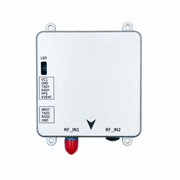
HB56H GNSS Heading Receiver with SD Logging — Septentrio mosaic-H
Flange-mount dual-antenna heading receiver with on-board SD card logging
- Septentrio mosaic-H, multi-constellation, dual-frequency
- Dual-antenna heading: 0.15° with 1 m baseline, 0.03° with 5 m
- Centimetre-level RTK: 0.6 cm + 0.5 ppm, 7 s initialisation
- RTK + attitude at 20 Hz, raw measurements at up to 100 Hz
- AIM+ anti-jamming, LOCK+, IONO+, APME+ and RAIM+
- SD/MMC card slot for on-board raw data logging
- Metal enclosure with four mounting ears, 13 mm thick, 60 g
No forms to fill in — we reply within one business day.
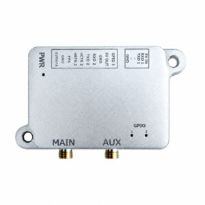
GNSS heading receiver with SD logging in a flange-mount metal housing
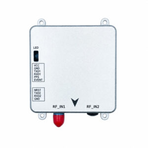
The Eview HB56H is a GNSS heading receiver with SD logging, powered by the Septentrio mosaic-H: two antenna inputs give centimetre-level RTK position plus true heading and pitch or roll, and an SD/MMC card slot records raw data on the receiver itself. The flat metal enclosure has four screw-mount ears, so it fixes directly to a vessel, machine or robot. Learn how dual-antenna GNSS heading works. The HB56H is part of our mosaic-H box receivers; the single-antenna HB56 shares the same housing.
Heading without motion or a magnetic compass
The Septentrio mosaic-H computes heading from the baseline between two antennas, so it is valid at standstill and is not affected by steel structures or magnetic disturbance. Accuracy is 0.15° heading and 0.25° pitch or roll with a 1 m baseline, improving to 0.03° and 0.05° with 5 m. RTK position and attitude are output together at up to 20 Hz. See GNSS attitude from a moving base.
AIM+ anti-jamming
Septentrio AIM+ shows an interference indicator and spectrum view, and suppresses narrowband and wideband interference, so the HB56H keeps position and heading near radios, engines and power electronics. Learn more about anti-jamming GNSS receivers.
GNSS+ technologies
LOCK+ keeps tracking stable under vibration and shock. IONO+ protects RTK accuracy during ionospheric scintillation (why RTK drops after sunset). APME+ reduces multipath from water, buildings and metal structures. RAIM+ monitors position integrity.
On-board logging and easy integration
The SD/MMC card slot stores complete raw data for post-processing or as a record of each mission. Two UARTs, PPS output and an event input are on two pin headers, and Micro USB connects to a PC for setup and downloads. The HB56H accepts RTCM v2.x/v3.x (including MSM) and CMR corrections, and outputs NMEA 0183 (including heading messages), Septentrio SBF and RTCM. See our guide to NTRIP, RTCM and RINEX integration. Firmware and manuals are on our firmware downloads page.
Applications
- Marine and USVs: GNSS compass heading for vessels and unmanned surface vessels.
- Robots and AGVs: heading at standstill for outdoor robots and autonomous vehicles.
- Construction and mining: position and orientation for excavators, dozers and drill rigs.
- Precision agriculture: heading for auto-steering and implement control.
- UAVs and drones: GNSS yaw for flight near magnetic interference.
- Vehicles and logistics: position and heading for test vehicles and yard trucks.
Frequently asked questions
What is the difference between the HB56H and the HB56?
The HB56H uses the Septentrio mosaic-H with two antenna inputs and outputs heading and pitch or roll. The HB56 uses the mosaic-X5 with one antenna for positioning at up to 100 Hz and more signals, including L5, E5a and E6. Both share the same enclosure and interfaces.
How accurate is the HB56H heading?
0.15° heading and 0.25° pitch or roll with a 1 m antenna baseline, and 0.03° / 0.05° with a 5 m baseline. A longer baseline gives better accuracy.
How is the HB56H different from the HB50H?
The HB56H uses the mosaic-H in a metal housing with mounting ears. The HB50H uses the mosaic-G5 P3H, which tracks more signals, in a lighter compact housing.
Can the HB56H log raw data?
Yes. It records raw measurements to an SD/MMC card. Septentrio SBF files can be converted to RINEX for post-processing.
How do I get the full HB56H datasheet or a quote?
Email sales@gnss-solutions.com for the complete datasheet, or ask a quote with your application and quantity.
Related reading
HB56H specifications
| GNSS engine | Septentrio mosaic-H, 448 hardware channels |
|---|---|
| Versions | HB56H: dual antenna, positioning + heading · HB56: single antenna, positioning (mosaic-X5) |
| GNSS signals | GPS L1C/A, L2C, L2P(Y) · GLONASS L1C/A, L2C/A · Galileo E1, E5b · BeiDou B1I, B2I, B3I · QZSS L1C/A, L1C/B, L2C · SBAS L1 |
| RTK accuracy (RMS) | 0.6 cm + 0.5 ppm horizontal, 1 cm + 1 ppm vertical |
| Heading / pitch-roll accuracy | 0.15° / 0.25° (1 m baseline); 0.03° / 0.05° (5 m baseline) |
| RTK initialisation | 7 s |
| Update rate | Measurements up to 100 Hz; position + attitude up to 20 Hz (RTK), 50 Hz (standalone/SBAS/DGNSS) |
| Latency | <10 ms |
| Velocity accuracy | 3 cm/s |
| Time to first fix | Cold <45 s, warm <20 s, reacquisition 1 s |
| Timing accuracy | xPPS 5 ns, event <20 ns |
| Data formats | RTCM v2.x/v3.x (incl. MSM) in/out, CMR v2.0, CMR+ (input), NMEA 0183 v2.3/v3.03/v4.0, Septentrio SBF, RINEX v2.x/v3.x |
| Interfaces | 2 × UART, Micro USB, PPS output, event input, SD/MMC card slot, 2 × SMA antenna inputs |
| Dimensions / weight | 76 × 69 × 13 mm including mounting ears; 60 g |
| Environmental | Operating −40 to +85 °C, storage −55 to +85 °C, humidity 5–95 % non-condensing |
| Complete datasheet | On request: sales@gnss-solutions.com |
Product datasheet
The complete datasheet (GNSS signals, interfaces, pin-out, electrical and environmental specifications) is available on request. Email sales@gnss-solutions.com with the product name and your application.
Support documentation
Ask a quote or contact our engineers for integration support.