GNSS in High-Dynamic Operations: Velocity Accuracy, Turns and What to Test
Short answer: in high-dynamic work, such as fast drone mapping, survey vehicles or agile robots, GNSS performance depends on more than top speed. Acceleration, turns and the antenna’s changing view of the sky all matter. A published vehicle study found Doppler-based velocity errors of about 0.05–0.15 m/s on an open road, against 0.17–0.86 m/s for time-differenced pseudoranges. In an urban canyon, carrier-phase velocity was available 77% of the time with GPS alone and 97% with BeiDou. To judge a receiver for high-dynamic work, test velocity, availability and continuity on your own platform, not just position accuracy.
Updated October 2026. This article reviews published studies and a Septentrio case study. It is not an Eview test, and the numbers below are not specifications of any Eview product.
What “high-dynamic” really means for GNSS
A platform moving at a constant 20 m/s in a straight line is easy for a modern receiver to follow. The hard parts are changes:
- Linear dynamics: acceleration, braking and jerk, which the receiver’s tracking loops and navigation filter must follow without lagging or overshooting.
- Angular dynamics: turns, banking and vibration. They change which satellites each antenna can see and can cause short losses of lock.
- Environment: buildings, trees and the airframe itself block or reflect signals, so the number of usable satellites changes from second to second.
To describe GNSS performance in fast operations, report linear and angular motion separately, and give position or velocity error, solution availability, continuity and the reference system together.
Evidence 1: GNSS velocity accuracy on a moving vehicle
Ji, Sun, Cheng and Wang (2022, Satellite Navigation) compared four ways of computing velocity from GNSS. They used a car-mounted multi-GNSS receiver logging at 10 Hz (not a Septentrio-based unit), with a post-processed high-grade IMU + RTK system as the reference. Test 1 ran on a lightly built-up main road; test 2 ran through an urban canyon with tall buildings.
| Method | What it uses | What the study observed |
|---|---|---|
| Raw Doppler (RD) | Doppler shift measured in the current epoch | Follows rapid speed changes closely; the authors rate it best for high dynamics |
| Time-differenced pseudorange (TDPR) | Change in code range between epochs | Simple, but multipath makes it noisy, especially when moving |
| Time-differenced carrier phase (TDCP) | Change in carrier phase between epochs | High accuracy in open sky; signal interruptions and cycle slips hurt continuity |
| Double-differenced carrier phase (DDCP) | Carrier phase differenced between satellites and epochs | High accuracy, but needs enough continuously tracked satellites |
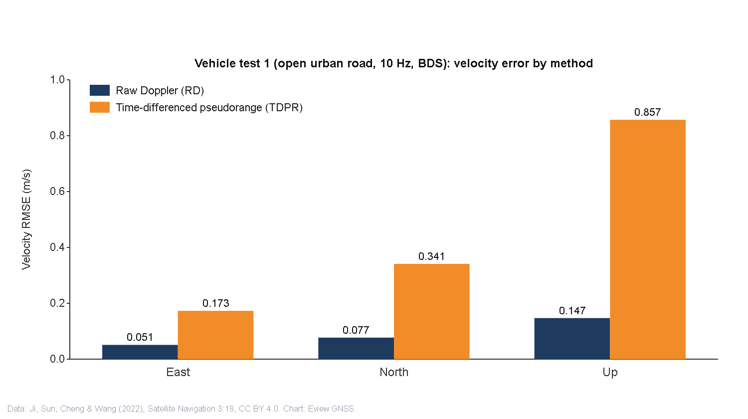
Test 1 (open road, BDS): raw Doppler gave a velocity RMSE of 0.051 m/s east, 0.077 m/s north and 0.147 m/s up. TDCP and DDCP stayed below 0.1 m/s horizontally and 0.2 m/s vertically. TDPR was clearly worse at 0.173, 0.341 and 0.857 m/s, with peak errors of several metres per second.
Test 2 (urban canyon): buildings increased multipath and lock loss. Raw Doppler RMSE with GPS was 0.104 m/s east and 0.142 m/s north; with BDS, which had more satellites in view, it was 0.081 and 0.085 m/s. The bigger difference was availability. DDCP produced a solution in 77.14% of epochs with GPS alone and 96.60% with BDS, and combining GPS and BDS improved it further.
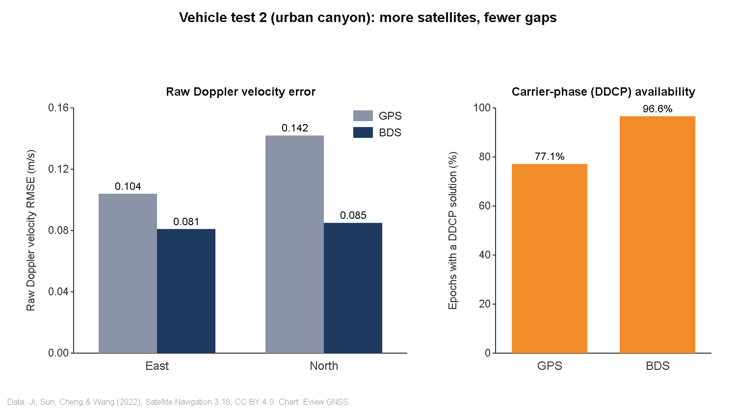
How to read it: these are velocity errors in metres per second, not position errors in centimetres, so they do not tell you how accurate an RTK position is. They do show three things that matter for fast platforms. Doppler-based velocity copes well with rapid changes. Carrier-phase methods are accurate but depend on continuous tracking. And more constellations mean fewer gaps.
Evidence 2: drone mapping speed comes from the workflow
Septentrio’s case study Look, no Ground Control Points! describes a quarry closed after a landslide. A fixed-wing drone carrying a Septentrio AsteRx-m UAS receiver mapped about 7.5 ha (18.5 acres) in a 15-minute flight and took 143 photos. The receiver logged dual-frequency GNSS data together with the camera’s shutter events. After the flight, the logs were processed against base station data (PPK) and the photo positions were updated. Checked against 20 independent checkpoints, the photogrammetry results reached a 3D RMS error better than 3.5 cm in two different processing packages, with no ground control points.
Two cautions. The 3.5 cm figure is a post-processed mapping result checked against ground points, not real-time flight accuracy. And the gain is in the workflow: no time spent laying out ground control, and no live correction link needed during the flight. For more on this choice, see RTK vs PPK for drone mapping.
Turns, rotation and the antenna’s view of the sky
Fast linear motion and fast rotation are different problems. When a platform banks or spins, each antenna’s gain pattern turns with it, so satellites can drop below the useful part of the pattern for a moment. A satellite that loses lock has to be re-acquired, and its broadcast data decoded again, before it counts towards the solution again. That is why a sharp turn can cost more continuity than a high straight-line speed. Practical consequences for drones, survey vehicles and robots:
- Mount the antenna where the airframe, payload or vehicle body does not shade it during turns or banking.
- Use multi-band, multi-constellation tracking so a short loss on some satellites still leaves enough for a solution.
- Log satellite count and fix status through the manoeuvres you actually fly or drive, not only on straight lines.
- For heading during tight turns, a dual-antenna GNSS heading setup or GNSS/INS fusion is more robust than course-over-ground.
Receiver dynamics settings: responsiveness vs noise
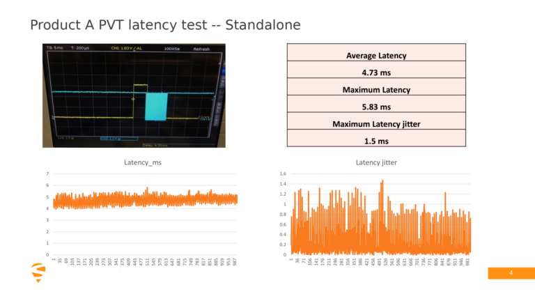
Septentrio receivers let you tell the navigation filter what kind of motion to expect. The AsteRx SB3 Pro+ reference guide (firmware 4.10.1) describes a motion type (for example UAV, RaceCar or Automotive) and a dynamics level. “Moderate” is the recommended default. Higher levels follow shocks, vibration and fast changes in position more quickly, at the cost of more noise. “Max” turns off the navigation filter so that each epoch is computed independently, which can also add PVT output latency. Check the reference guide for your receiver model and firmware before relying on a particular option.
The point is that high-dynamic performance is not just a matter of turning everything up. Match the setting to the platform’s speed, turn rate and vibration, then measure noise and output latency. Our article on GNSS update rate, latency and jitter explains why output timing matters as much as accuracy for control loops.
How to test GNSS for high-dynamic operations
| Report clearly | Avoid |
|---|---|
| Receiver, firmware, antenna, mounting, sampling rate, platform and route | Combining numbers from different studies or models into one product claim |
| Whether the metric is position or velocity, horizontal or vertical, RMSE or maximum error | Quoting a velocity error in m/s as if it were position accuracy in cm |
| Real-time RTK or post-processed, and the independent reference used | Presenting a post-processed photogrammetry RMS as real-time flight accuracy |
| Linear speed and acceleration separately from turn rate | Converting an angular rate in °/s into a vehicle speed |
| Solution availability and continuity, including the worst segments | Averages that hide short outages during manoeuvres |
A good test logs raw observations, fix status and velocity on the target platform during the manoeuvres that matter, compares them against an independent reference, and repeats the run. For an example of reporting fix status honestly in difficult conditions, see our field review of RTK under tree canopy.
Where Eview receivers fit
Eview receivers are built on Septentrio mosaic modules with multi-band, multi-constellation tracking, AIM+ interference protection and high-rate output. For drone mapping with RTK or PPK, see the UAV GNSS solutions and the best RTK GNSS receivers for drone mapping. For heading during turns, the HB6 Pro uses the dual-antenna mosaic-H. For ground robots and vehicles, see robotics GNSS receivers. Tell us your platform speed, turn rates and output rate, and we will suggest a configuration to test: sales@gnss-solutions.com.
FAQ: GNSS in high-dynamic operations
How accurate is GNSS velocity? In the vehicle study reviewed here, Doppler-based velocity had an RMSE of about 0.05–0.08 m/s horizontally and 0.15 m/s vertically on an open road, and about 0.08–0.14 m/s horizontally in an urban canyon. Time-differenced pseudorange velocity was several times worse.
Which GNSS velocity method is best for high dynamics? The study’s authors found raw Doppler best for highly dynamic motion, because it is measured in each epoch and follows rapid changes. Carrier-phase methods can be very accurate but need continuous tracking.
Is GNSS velocity error the same as position error? No. Velocity error is measured in metres per second and position error in metres or centimetres. A receiver can have centimetre RTK position and decimetre-per-second velocity noise at the same time, so report each separately.
Do sharp turns affect GNSS more than high speed? They can. Turning or banking rotates the antenna’s gain pattern, which can cause short losses of lock on some satellites. Multi-constellation tracking, good antenna placement and dual-antenna heading or GNSS/INS help keep the solution continuous.
Which receiver dynamics setting should I use on a drone? Start with the motion type that matches the platform (for example UAV) at the default “Moderate” level. Raise the level only if logs show the solution lagging during manoeuvres, and check the extra noise and output latency.
Sources and credits
- Ji, L., Sun, R., Cheng, Q. and Wang, J. (2022). Evaluation of the performance of GNSS-based velocity estimation algorithms. Satellite Navigation 3, 18. doi:10.1186/s43020-022-00080-4. Open access under CC BY 4.0. Charts in this article were redrawn by Eview GNSS from the paper’s reported values.
- Septentrio. Look, no Ground Control Points! (AsteRx-m UAS case study). septentrio.com.
- Septentrio. AsteRx SB3 Pro+ Reference Guide, firmware 4.10.1 (receiver dynamics settings). Available from septentrio.com support resources.
Research compiled by the Eview technical team; written by Jack W.