GNSS/INS Sensor Fusion: How FUSE+ Keeps Position Steady When GNSS Degrades
Updated November 2026
Is GNSS/INS fusion automatically better than GNSS alone? Only when the fusion engine knows how much to trust the GNSS measurements it is fed. Adding an IMU to a receiver gives you continuity; it does not give you accuracy, because the inertial solution is anchored to the GNSS solution — errors included. This article explains what Septentrio’s FUSE+ does differently, what the engine takes in and puts out, and how to decide whether you need a fused GNSS/INS receiver or a dual-antenna heading receiver for the job.
Short answer: FUSE+ is Septentrio’s GNSS-aware sensor fusion. Instead of treating every GNSS measurement as equally good, it evaluates measurement reliability first, then fuses GNSS with IMU and vehicle-motion data inside one navigation engine. The output is position, velocity, heading, pitch and roll that stay continuous through short signal loss, stay stable under multipath, and recover faster when the sky opens up again. If your problem is orientation at low speed rather than continuity through an outage, a dual-antenna heading receiver — HB56H, HB50H or HB10, all powered by Septentrio — solves it without an IMU at all.
Why a GNSS receiver alone runs out of road
In open sky a modern multi-constellation receiver holding an RTK fix is a hard thing to beat: centimetre repeatability, no drift, no warm-up. The trouble is that the sentence has a precondition — open sky — and most machines worth positioning do not work under one.
The failures cluster into three groups, and they damage three different properties of the solution. Keeping them apart is what makes a receiver specification readable.
- Blockage costs availability. Buildings, tunnels, dense canopy and the machine’s own structure cut the line of sight to satellites. Satellite count drops, geometry worsens, and the solution walks down the quality ladder from fixed to float to standalone. The problem is not that the position is wrong; it is that there is no position.
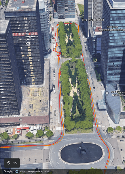
- Reflection costs accuracy. Multipath — signals arriving after bouncing off a wall, a container stack or a metal roof — puts bias on code and carrier measurements. The solution still exists, but it jumps, spikes and wanders. It is present and not to be trusted.
- Interference and hard dynamics cost integrity. An elevated noise floor, an aggressive acceleration or heavy vibration changes measurement quality faster than a conventional filter can react. Here the hard question is not “how accurate is this position” but “is this position usable at all”.
The engineering reflex is to add an IMU: GNSS supplies the absolute anchor, the inertial unit carries the solution through the tens of milliseconds to tens of seconds where satellites are missing. That reflex is correct. What differs between products is the thing that decides whether it works — how the engine judges the GNSS measurements before they enter the filter.
What GNSS/INS sensor fusion is, and the step most systems skip
GNSS/INS sensor fusion puts the receiver’s positioning output — and, in tightly coupled architectures, the underlying measurements — into the same navigation filter as the accelerations and angular rates from an IMU. The two are physically complementary. GNSS gives an absolute, drift-free reference; the IMU gives high-rate motion that does not care about sky view.
| Property | GNSS alone | GNSS/INS fusion |
|---|---|---|
| Position source | Absolute solution from satellite observations | GNSS absolute solution constrained by inertial propagation |
| Behaviour over time | No drift, but jumps and drop-outs are visible | Continuous and smooth; errors accumulate only while GNSS is absent |
| Outputs | Position and velocity; heading inferred from track | Position, velocity, heading, pitch, roll |
| During blockage | Fix lost or degraded | Dead reckoning bridges the gap, then GNSS is re-admitted |
| Dependence on GNSS quality | Direct | Indirect but absolute — a biased anchor biases the fused solution |
The concept that makes continuity possible is dead reckoning: from the last trusted GNSS solution, the engine integrates acceleration and rotation, plus any vehicle-motion input available, to keep producing a position while the sky is blocked. Accuracy decays with time and with inertial grade, but continuity holds. For a machine controller, “continuous and slowly degrading” is worth far more than “accurate until it disappears”.
The step that most fusion systems skip is deciding whether a given GNSS measurement deserved to be in the filter in the first place. Treat GNSS observations as uniformly reliable and a multipath-biased fix enters the solution at full weight; the IMU then faithfully propagates that bias forward. The price is paid later, in three places: position error spreading through the navigation solution, a slower re-convergence after the outage ends, and an integrity figure that no longer means anything.

What FUSE+ actually does
FUSE+ is built on more than 25 years of GNSS receiver design, and the GNSS part of that heritage is the product: the engine continuously assesses the reliability of GNSS measurements and adapts as conditions change, rather than assuming every observation is equally good. When quality drops — low elevation, weak signal, residual growth, interference — the affected measurements are down-weighted or rejected instead of being averaged into the solution at full strength.
Two consequences follow that matter on a machine:
- Integrity is cross-checked, not asserted. Independent sensor inputs are used to cross-check the GNSS measurements, which is what makes a confidence statement about the position output meaningful. FUSE+ works alongside AI-powered interference mitigation and integrity monitoring rather than replacing them — see our explainer on Septentrio RAIM+ integrity monitoring for how the statistical test side works.
- Recovery is faster. A filter that was not dragged off by bad observations does not need to re-converge from far away when the satellites come back. In practice that difference shows up as fewer seconds of float after a tunnel, an underpass or a pass beneath a loader.
Inputs, outputs and the structure of the engine
The architecture is easier to specify once you see what crosses the boundary. FUSE+ combines GNSS receiver measurements with IMU data and additional motion inputs inside a single GNSS/INS integration engine.
| Into the engine | Out of the engine |
|---|---|
| GNSS receiver measurements (position, velocity, and the quality information behind them) | Position |
| IMU acceleration and angular rate | Velocity |
| Vehicle velocity information (wheel speed, odometry, or another source matched to the machine) | Heading |
| Additional motion inputs, where the architecture provides them | Pitch and roll |
Table 2 — FUSE+ inputs and outputs.
Note what the input column implies for integration. Velocity information and motion inputs are not decoration: they are what keeps the inertial propagation honest on a vehicle that accelerates, brakes, reverses and works on a slope. A wheel-speed source that lies — spinning on a wet headland, for instance — will mislead the filter, which is why the source has to be matched to the machine rather than chosen for convenience.
Five failure modes FUSE+ is designed around
| Condition | What it does to positioning | How the fusion responds | What the operator sees |
|---|---|---|---|
| Temporary signal blockage (building, tunnel, canopy, machine structure) | Fix interrupted or lost | Inertial dead reckoning bridges the gap until GNSS returns | The job continues; no reset, no re-initialisation |
| Degraded measurements (low elevation, weak signal) | Confidence in the solution falls | Measurement reliability is re-evaluated and weighted accordingly within one engine | Steadier output through changing sky conditions |
| Multipath and reflected signals | Bias, jumps and spikes in position | Inertial measurements constrain the solution while APME+ mitigates multipath on the GNSS side | Fewer visible spikes, less steering correction |
| Hard vehicle dynamics (rapid motion, vibration) | Navigation performance swings | GNSS, IMU and optional motion inputs are combined continuously | Smoother machine behaviour at speed |
| Need for orientation | Guidance and control need more than a point on a map | GNSS plus inertial gives position, velocity, heading, pitch and roll | A control loop that can actually use the attitude |
Table 3 — The five conditions FUSE+ is specified against, and the operational effect of each.
Two of these have been examined on this site before with data rather than theory. The velocity question under aggressive motion is covered in GNSS in high-dynamic operations, and the multipath-and-interference problem in an industrial yard appears in GNSS receivers for mining.
Orientation: the half of the problem an IMU is not always the answer to
Plenty of projects that ask about GNSS/INS fusion do not have an outage problem at all. They have an orientation problem. A guidance system needs to know which way the machine faces before it moves — at standstill, at 0.5 km/h, on a slope, and after a headland turn where the track-derived course is meaningless for several seconds.
Single-antenna receivers infer heading from the direction of travel. That inference collapses exactly when machine control needs it most. A dual-antenna receiver measures heading from the geometry between the two antennas, so the value is valid with the vehicle stationary and is not disturbed by the metal, motors or alternator around it. With a 1 m baseline the heading figure is 0.15°, improving as spacing increases.
That makes the choice a specification question rather than a budget question:
- Need orientation at low speed and standstill, no outage bridging — HB56H (mosaic-H heading receiver with SD logging) or HB50H (mosaic-G5 P3H, heading plus pitch or roll). Both are covered in depth in our dual-antenna heading guide.
- Need the board form factor with the same logic — HB10, a compact dual-antenna RTK receiver powered by Septentrio AsteRx-m3 Pro.
- Need continuity through outages as well, in a fused GNSS/INS receiver — that is the AsteRx-i3 and RBi3 class, where FUSE+ lives. Talk to us about the configuration rather than picking from a web page.

What to check before you integrate a fused solution
Fusion moves a share of the accuracy budget out of the receiver and into the installation. The three items that most often undo a good receiver:
- Lever arm and mounting. The IMU must be rigidly mounted and its offset from the GNSS antenna entered correctly. A lever arm error shows up as a systematic attitude offset, not as noise, so it survives every calibration that only looks at repeatability.
- Re-calibration after mechanical change. Moving the antenna or the IMU — including “small” bracket changes during a retrofit — invalidates the geometry. Re-survey the offsets and redo the alignment.
- Velocity source matched to the machine. Wheel speed on a machine that can slip, spin or lock is a suspect input. Where that is the operating reality, down-weight it or take velocity from a source that survives the condition.
Two more that cost nothing to get right: keep the GNSS side as clean as the fusion side — interference filtering and antenna placement are still the foundation, as described in anti-jamming GNSS — and log raw data during commissioning. An HB56 with SD logging, or a receiver with SBF logging enabled, turns an argument about what happened in the field into a file you can replay.
Which receiver for which problem
| Problem you actually have | What solves it | Typical platform |
|---|---|---|
| Position drifts or drops in obstructed areas, and the machine must keep working | Fused GNSS/INS receiver with FUSE+ (AsteRx-i3 D Pro, RBi3 class) | Autonomous machines, port and yard equipment, mining plant |
| Heading, pitch or roll needed at low speed or standstill | Dual-antenna heading receiver: HB56H, HB50H, HB10 | Agriculture, robotics, survey vehicles |
| Centimetre positioning plus raw data for post-processing | HB56 — mosaic-X5, SD card logging | Mapping, machine guidance, monitoring |
| Corrections at the source, independent of a network | HB62 base receiver | Farms, mines, construction sites |
Table 4 — Matching the receiver class to the failure you are trying to remove.
Platform context is worth reading alongside this: GNSS for robotics, autonomous vehicles and construction and mining each put the same receiver under a different duty cycle. For robot platforms specifically, outdoor mobile robot positioning covers the driver and interface side, and the ROSaic driver guide covers bringing fused receivers into ROS.
Frequently asked questions
What is the difference between GNSS/INS and GNSS alone?
GNSS alone derives position from satellite observations. GNSS/INS adds an inertial measurement unit and fuses accelerations and rotations with the GNSS solution, so the system keeps producing position and attitude when GNSS is briefly interrupted, and outputs heading, pitch and roll that a GNSS-only receiver cannot supply at standstill.
Does adding an IMU improve RTK accuracy?
No. RTK accuracy still comes from the GNSS solution. Fusion improves continuity, smoothness and attitude, and it protects the solution from being dragged around by bad measurements — but a biased GNSS anchor produces a biased fused solution. That is why a GNSS-aware engine that evaluates measurement quality matters more than the inertial grade alone.
What does “GNSS-aware” mean in FUSE+?
It means the fusion engine continuously evaluates the reliability of GNSS measurements and weights or rejects them accordingly, instead of treating all observations as equally trustworthy. The approach comes out of Septentrio’s GNSS receiver design work rather than from an inertial-navigation background.
How long can position hold without GNSS?
It depends on inertial grade, calibration quality and how the vehicle moves during the gap — a stationary machine holds far longer than one accelerating over rough ground. Treat any number quoted without those conditions as marketing, and confirm actual figures against the receiver’s datasheet for your IMU option.
Can FUSE+ take wheel speed, odometry, LiDAR or camera data?
Additional motion inputs and vehicle velocity information can be brought into the engine where the architecture supports them. Which sources are accepted depends on the receiver model, the available interfaces and the vehicle; confirm during selection rather than after installation.
Do I need a fused receiver if I only want heading?
Usually not. A dual-antenna heading receiver gives true heading, and pitch or roll, from the antenna baseline — available at standstill, with no drift, no alignment procedure and no IMU calibration. If the requirement is orientation at low speed rather than continuity through a blockage, dual antenna is the simpler answer.
Ask us to match the engine to the machine
The useful input from your side is not a model number, it is the failure: where the position degrades, for how long, what the machine is doing at the time, and whether the missing information is position or orientation. Send that and we will tell you whether the answer is a fused GNSS/INS receiver, a dual-antenna heading receiver, better logging, or simply a better mount.
Email sales@gnss-solutions.com with your platform, the environment it works in, and the symptom you are trying to remove.
Sources and figure credits. Figures 1–3 are reproduced from Septentrio’s FUSE+ sensor fusion page (septentrio.com — FUSE+ sensor fusion); the technology description, input/output set and the five challenge categories in this article follow that page. Tables 1–4 and the integration guidance are our own.